Mengjie Lu, Zhen Zhang, Peng Chen, Changxin Xu, Bin Gao, Luzhang Ruan. 2024: Shallow sub-lakes are essential for sustaining the successful wintering of waterbirds in Poyang Lake, China. Avian Research, 15(1): 100178. DOI: 10.1016/j.avrs.2024.100178
Citation:
Mengjie Lu, Zhen Zhang, Peng Chen, Changxin Xu, Bin Gao, Luzhang Ruan. 2024: Shallow sub-lakes are essential for sustaining the successful wintering of waterbirds in Poyang Lake, China. Avian Research, 15(1): 100178. DOI: 10.1016/j.avrs.2024.100178
Mengjie Lu, Zhen Zhang, Peng Chen, Changxin Xu, Bin Gao, Luzhang Ruan. 2024: Shallow sub-lakes are essential for sustaining the successful wintering of waterbirds in Poyang Lake, China. Avian Research, 15(1): 100178. DOI: 10.1016/j.avrs.2024.100178
Citation:
Mengjie Lu, Zhen Zhang, Peng Chen, Changxin Xu, Bin Gao, Luzhang Ruan. 2024: Shallow sub-lakes are essential for sustaining the successful wintering of waterbirds in Poyang Lake, China. Avian Research, 15(1): 100178. DOI: 10.1016/j.avrs.2024.100178
School of Life Sciences, Nanchang University, Nanchang, 330031, China
b.
Jiangxi Province Key Laboratory of Watershed Ecosystem Change and Biodiversity, Center for Watershed Ecology, Institute of Life Science and School of Life Sciences, Nanchang University, Nanchang, 330031, China
Funds:
the Poyang Lake Water Conservancy Project Office of the Department of Water Resources, Jiangxi Province, ChinaKT201537
the National Natural Science Foundation of China32360285
the National Geographic Air and Water Conservation FundGEFC07-15
For migratory waterbirds, the quality of wintering habitat is related to spring migration and successful breeding in the next year. The availability of food resources in the habitat is critical and varies within water levels. Although the water-level fluctuations in Poyang Lake have been extremely variable interannually in recent years, the wintering waterbird populations have remained relatively stable. Hence, the mechanism of maintaining the stability is worth exploring. This study aimed to compare the distribution of vegetation and herbivorous waterbirds in 2015–2016 and 2016–2017, focusing on three shallow sub-lakes and one main lake are. The results showed that the emergence of tubers and the growth of Carex spp. provided a continuous food supply and habitat for wintering waterbirds with a gradual decline in the water level. Shallow sub-lakes supported almost all of the tuber-eating waterbirds (1.42–1.62 × 10⁵) and most geese (1.34–1.53 × 10⁶). However, the main lake area, covered with Persicaria hydropiper, did not provide adequate and accessible food. This resulted in almost no distribution of tuber-eating waterbirds, with only a few geese congregating in early winter. Our results demonstrated that the shallow sub-lakes under human control provided a different environment from the main lake and are key to sustaining the successful wintering of hundreds of thousands of migratory waterbirds in Poyang Lake. Therefore, we recommend refining the anthropogenic management of the shallow sub-lakes to regulate the water level to ensure the carrying capacity of Poyang Lake.
In autumn, billions of birds migrate from breeding sites to wintering sites globally (Xu, 2021). In the northern hemisphere, migratory birds that go south escape the cold of north and the winter-related food shortage (Newton, 2008). Compared with resident birds, migratory birds are more vulnerable to the negative impacts of habitat loss (Wilcove and Wikelski, 2008; Zhang et al., 2018). Also, 4000 species of migratory birds exist globally (Kirby et al., 2008), with wintering waterbirds being a significant taxon. For migratory waterbirds, the quality of wintering habitat is critical, as it directly influences successful spring migration and reproduction in the following year (Norris, 2005; Xia et al., 2010).
A desirable wintering habitat requires an adequate quantity of food with sustainable availability (Wang et al., 2013a, b), both of which are associated with hydrological process (Holm and Clausen, 2006; Baschuk et al., 2012). Adequate food is essential for waterbirds to undergo a successful wintering (Jia et al., 2013). The water level can affect the process of plant development, thus limiting the foraging of herbivorous waterbirds (González-Gajardo et al., 2009; Baschuk et al., 2012; Zhang et al., 2014a). For example, the long-term high water levels can lead to significant decreases in the density and biomass of vegetation in the wet season (Doyle and Smart, 2001; Yuan et al., 2012), which is unfavorable for cranes and Tundra Swans (Cygnus columbianus) (Van Geest et al., 2005). In addition, the sustainable availability of food is even more critical. In the dry season, reasonable water levels are conducive to successful foraging by various waterbirds (Jiang et al., 2014). However, if the water level drops rapidly, the early emergence of the lakeshore allows for the early development of Carex spp., rapid senescence, and hardening of the soil (affecting submerged vegetation accessibility), which decreases the availability of food resources (Klein et al., 2005; Zhang et al., 2011; Li et al., 2018).
Poyang Lake is a desirable habitat for migratory birds, providing food and habitat for hundreds of thousands of wintering birds each year (Hou et al., 2020; Hu et al., 2015). It had low water levels in the dry season since 2003 (Mei et al., 2016). The water levels have fallen faster, leading to an earlier and longer dry season in recent years (Li et al., 2019b). The water level is also extremely variable, which is not conducive to herbivorous wintering waterbirds. However, the monitoring data (from surveys of wintering waterbirds around Poyang Lake organized by the Jiangxi Wildlife Conservation Center, China) and related literature (Zhu et al., 2012; Li et al., 2019a; Wang et al., 2019) indicate that the number of wintering waterbirds ranges from 500, 000 to 700, 000 since 2000. The wintering waterbird populations have remained relatively stable. Moreover, wintering waterbirds in the middle and lower reaches of the Yangtze River are concentrated in Poyang Lake wetlands (Wang et al., 2017), with the proportion of waterbirds in Poyang Lake wetlands increasing from 26.87% in 2004 to 55.30% in 2015. The proportion in the Hunan and Anhui regions decreased significantly (Barter et al., 2005).
With water levels fluctuating unfavorably from year to year, there must be a steadying mechanism for Poyang Lake to ensure the successful wintering of hundreds of thousands of waterbirds. We hypothesized that the shallow sub-lakes played a significant role in sustaining wintering process of waterbirds and were crucial for the stability of the populations in Poyang Lake over the years. However, further exploration is needed to verify it. In this study, we had three shallow sub-lakes and one main lake area as sample sites. We compared the distribution of herbivorous waterbirds and vegetation conditions in two types of areas and estimated the carrying capacity of the waterbirds. Based on the study findings, we offer conservation recommendations for wintering waterbirds in Poyang Lake and other similar ecosystems.
2.
Materials and methods
2.1
Study area
Poyang Lake (28°24′–29°46′ N, 115°49′–116°46′ E) is located on the south side of the middle and lower reaches of the Yangtze River in the northern part of Jiangxi Province, China. It is the largest freshwater lake in China and a highly dynamic large floodplain wetland system (Zhang et al., 2014b). The water level of Poyang Lake fluctuates substantially over the year, with a variation of more than 10 m. When flooding subsides, wide floodplain wetlands are formed (Feng et al., 2012) and numerous sub-lakes emerge. The wetlands in Poyang Lake include 102 shallow sub-lakes with an area of 816.32 km2 (Hu et al., 2015).
The shallow sub-lakes are the seasonal lakes of Poyang Lake, which are exposed in the lakeshore in the dry season (Li et al., 2019b; Tan et al., 2019). The water depth and the water receding process are different from those in the main lake area in the dry season (Hu et al., 2015). In the wet season (April–September), the water level of Poyang Lake is high, causing the shallow sub-lakes to integrated with the main lake area, resulting in consistent water level fluctuations (Maia et al., 2018; Li et al., 2019b). In the dry season (October–April), the water level of Poyang Lake recedes and the shallow sub-lakes are detached from the main lake area (Li et al., 2019b; Liu et al., 2021).
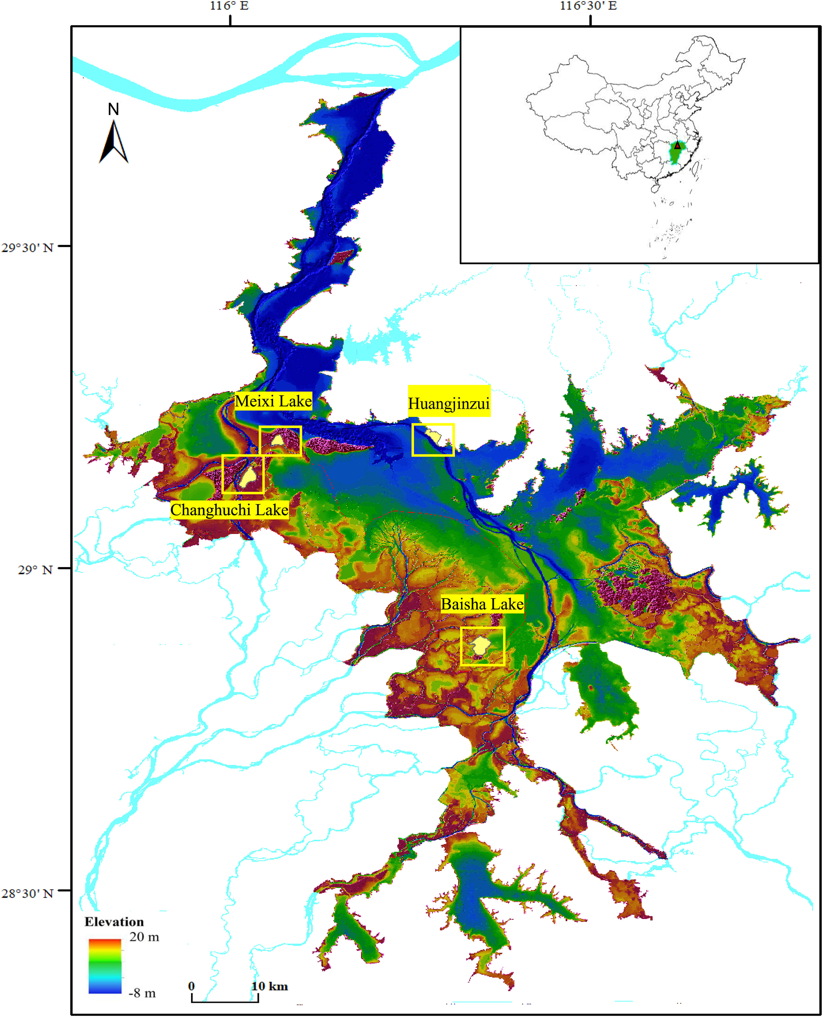
The four areas for this study were Meixi Lake, Changhuchi Lake, Baisha Lake (all three are shallow sub-lakes), and Huangjinzui—an area connected with the main lake. Meixi Lake (29°13′09.77ʺ N, 116°03′27.36ʺ E) is located in Poyang Lake National Nature Reserve, with an area of about 2.69 km2. It is integrated with the main lake of Poyang Lake in the wet season and separated when the water level declines to 15.8 m in the dry season (October to March), with the lowest elevation of the lake bottom at 12.8 m. Changhuchi Lake (29°08′09.93ʺ N, 115°59′22.43ʺ E) is located in Poyang Lake National Nature Reserve, with an area of about 5.29 km2; the separated water level is 15.6 m, and the lowest elevation is 12.4 m. Baisha Lake (28°54′41.60ʺ N, 116°19′50.35ʺ E) is located in Nanji Mountain National Nature Reserve, with an area of about 5.83 km2, the separation level is 14.1 m, and the minimum elevation is 11.7 m. Huangjinzui (29°13′41.30″ N, 116°16′05.34″ E) is located in the Duchang Migratory Bird Reserve, an area in the main lake, which turns into mudflats and river channels in the dry season and is representative of the main lake area (Fig. 1).
Figure
1.
Map of Poyang Lake wetlands and the distribution of the study sample sites. The areas in the four yellow boxes are the study sample sites.
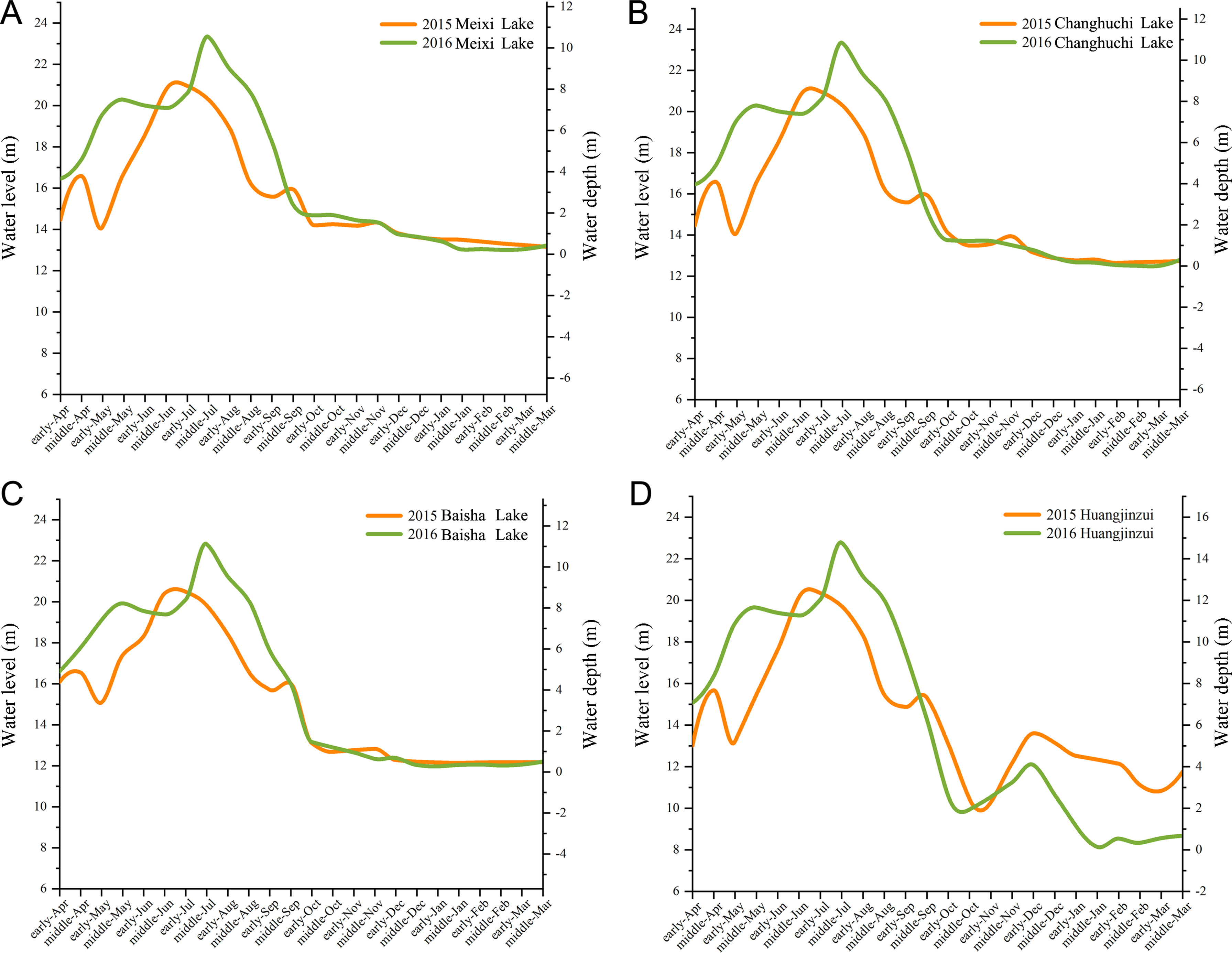
The water levels (Wusong Datum) of four lakes were surveyed in the early (around the 1st) and middle of the month (around the 15th) in 2015–2016 and 2016–2017. The water-level data were obtained from the nearest hydrological station in the wet season. In the dry season, the water-level data were monitored for each of the three shallow sub-lakes and the data from the Duchang hydrological station were used for Huangjinzui.
2.3
Waterbird surveys
During the two wintering seasons (the dry season) in 2015–2016 and 2016–2017, all herbivorous waterbirds were surveyed from October to March in four sample lakes. Surveys were conducted two times on the number of waterbirds in the study area each month, totaling 12 surveys. The waterbirds in this study included cranes (Siberian Crane Leucogeranusleucogeranus, Hooded Crane Grusmonachal, White-naped Crane Antigonevipio, Common Crane G. grus), geese (Bean Goose Anser fabalis, Swan Goose A. cygnoides, White-fronted Goose A. albifrons, Greylag Goose A. anser) and Tundra Swan (Cygnus columbianus). One or two permanent observation locations (fixed points) were established at each lake to ensure that the monitoring field covered the entire area and did not interfere with the behavior of the waterbirds. Observations were conducted for about 20–25 min to identify species and obtain accurate counts (Robinson and Pizo, 2017). We adopted the look–see counting method (Delany, 2005), and waterbird species were distinguished based on the parameters described by Mackinnon and Phillipps (2000) and Barter et al. (2005). Field surveys were conducted after sunrise under acceptable weather conditions, and global positioning system locations of waterbird distributions were recorded.
2.4
Vegetation surveys
Classification and identification of plants based on relevant illustrated books (Ge and Chen, 2015; Wang and Xu, 2016). Submerged vegetation (tubers) collections were taken on middle October 2016 and middle March 2017. The sampling methods were taken from the relevant literature (Yuan and Li, 2008; Li et al., 2015). The vegetation sampling points were investigated each time, including 20 from Meixi Lake, 16 from Changhuchi Lake, 34 from Baisha Lake, and 21 from Huangjinzui. The submerged vegetation surveys were conducted using a combination of sample lines and samples, with sample lines designed at 9″ intervals along the latitude and 12″ intervals along the longitude until the entire survey area was covered. Each sample line was spaced 300 m apart, and the intersection of the latitude and longitude sample lines was set as the sampling point (Appendix Fig. S1). The collection was set at a depth of 30 cm based on the analysis of waterbird foraging behavior, and carried out using a stainless-steel mud collector with a 5 cm tube diameter. Five collections were made per sample square and the mud collected was placed in a self-sealing bag with the sampling site amount recorded. The collected mud was sieved through a stainless-steel screen and the tubers were washed, sorted, and weighed (wet weights) using an electronic scale (0.001 g). The samples were oven-dried at 105 ℃ for 30 min and then dried at 55 ℃ for 2 days before being assessed for dry weight.
The lakeshore vegetation survey was conducted on early November 2016, with a total of 63 sample squares (Appendix Fig. S2) in four lakes (11 in Meixi Lake, 10 in Changhuchi Lake, 27 in Baisha Lake, and 15 in Huangjinzui), each of which was 1 m × 1 m; the vegetation cover and height of the sample squares were measured. The lakeshore vegetation was measured by referring to Meng (2018).
2.5
Statistical analysis
Water-level, waterbird, and plant biomass data were statistically analyzed using Origin 2018. Simulations of waterbird distribution were performed using ArcGIS 10.6 based on the water levels in middle November, early January, and middle February of 2016, depicting the impact of declining water levels. The correlation analysis of the ratio (R) between R0 (the linear distance from the center of the lake to the location of the cranes) and R1 (the linear distance from the center of the lake to the shore) was performed in the three shallow sub-lakes during a period of similar water level. The selected periods were from the middle January to early March in Meixi Lake, from early January to middle February in Changhuchi Lake, and from middle December to early March in Baisha Lake.
The wet weight was converted into the average biomass of the grid quadrat, and inverse distance weighted (IDW) was used to calculate the distribution map of submerged vegetation in sample lakes using ArcGIS 10.6. When determining the carrying capacity, the total biomass of submerged plants was calculated based on the dry weight biomass because most studies used the conversion of dry weight and energy, the total biomass of submerged plants was calculated based on the dry weight biomass. The total biomass on middle October 2016 was used as the main food source for tuber-feeding waterbirds during the wintering period.
In order to obtain the distribution of vegetation on the lakeshore, this study acquired Landsat TM/ETM images data on October 5, 2016, December 16, 2016, February 10, 2017, February 26, 2017, and Sentinel-2 images on November 3, 2016. The image data were obtained from the Geospatial Data Cloud (https://www.gscloud.cn/) and ESA (https://dataspace.copernicus.eu/), with little or no cloud cover for the study area. All images were pre-processed using ENVI 5.3, and the images were subjected to banding operations using the BAND MATH tool. For each image, we used the following formula to calculate an NDVI map, which was positively correlated with plant biomass (Klemas, 2013; Fuller and Wang, 2014):
NDVI=(NIR–R)/(NIR–R)
where NIR is the near-infrared reflectance, and R is the red reflectance of the images.
Based on the actual measurements of the vegetation on lakeshore in early November 2016, the vegetation was classified as low-coverage when it had < 50% cover and < 10 cm in height, and other instances were categorized as high-coverage vegetation (criteria derived from unpublished data). The NDVI map of Poyang Lake on November 3, 2016 was also used for verification (Appendix Fig. S2), NDVI values of 0.1–0.35 indicate low-coverage vegetation, and values > 0.35 indicate high-coverage vegetation.
The total biomass was calculated according to the fitted model of vegetation index and biomass (Meng, 2018): y = −4964x3 + 8850x2 – 3776x + 551.1.
In addition, the carrying capacity was estimated using the nutrient-carrying capacity, which was the ratio of the available energy provided within the habitat to the amount consumed by each individual (McCall and Bender, 1997; Jeffrey et al., 2009). Cranes and Tundra Swans mainly feed on tubers (Barzen et al., 2009), so the total energy produced by tubers in the shallow sub-lakes was the energy available. Geese mainly feed on Carex spp. < 10 cm in height (Wang et al., 2013a, b; Meng, 2018). Therefore, the energy produced by low-coverage vegetation (NDVI values 0.1–0.35) in Poyang Lake was considered as the energy source for geese. The carrying capacity of waterbirds is usually expressed as bird-days of the non-breeding season at migratory stopover sites, which is equal to the average number of days at the wintering site (van Eerden et al., 2010):
z=(a×h)/(b×d)
where z is the maximum number of waterbirds that the habitat can support; a is the energy produced per gram of tubers and Carex spp. (14.77 kJ/g for tubers and 15.4 kJ/g for Carex spp.); h is the total biomass of the habitat; b is the daily energy consumption of individual waterbirds, ranging from 2182 to 2484 kJ for a Tundra Swan or a crane, and 892–1275 kJ for a goose; and d is the days in the wintering period, taken as 150 (Wan, 2016; Meng, 2018).
3.
Results
3.1
Water level fluctuations
The water level in the 2016 wet season (April–September) was higher than that in 2015, and the water level > 15 m lasted longer. In the dry season, the water level of shallow sub-lakes overlapped in 2015 and 2016 and decreased over time, with a water depth of 0–2 m. The water level in the main lake district in 2016 was lower than that in 2015, and the time of depth decrease was also earlier than that in 2015. The water level in both years rose and then dropped rapidly after early December, with fluctuations. The difference in water depth was 3.3 m in 2015 and 3.9 m in 2016. In early December 2015, the water depth was closer to 6 m (Fig. 2).
Figure
2.
Water level fluctuations throughout the year. (A) Meixi Lake; (B) Changhuchi Lake; (C) Baisha Lake; (D) Huangjinzui.
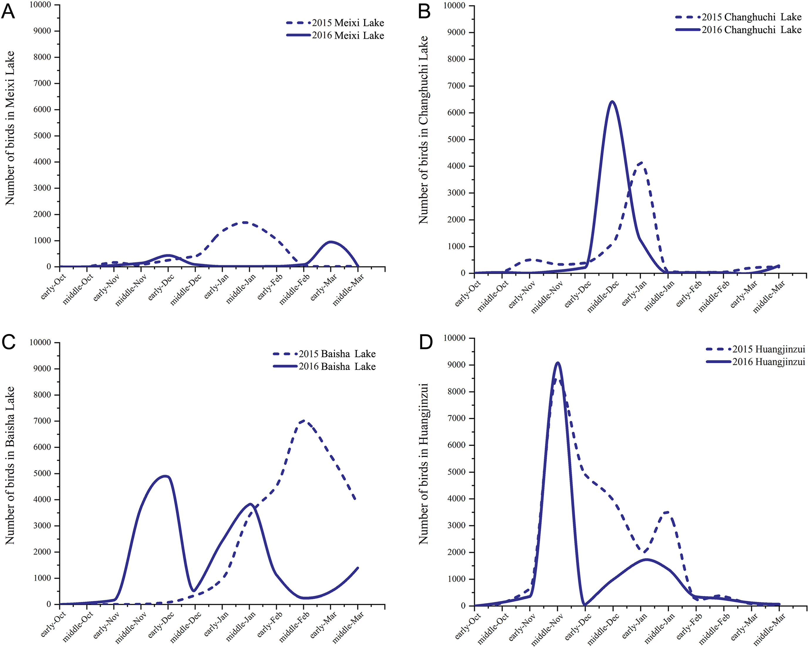
In shallow sub-lakes, the number of waterbirds peaked at different times in 2015 and 2016. In Meixi Lake, the peak occurred in middle January 2015 and early March 2016. In 2015, a large number of waterbirds were present at Changhuchi Lake in middle December, with a concentration of waterbirds in early January. Baisha Lake had more waterbirds in middle November and middle January 2015, whereas they were concentrated in middle February 2016. Huangjinzui had peak waterbird abundance in the middle November of 2015 and 2016, immediately followed by a sharp decrease. The number of waterbirds dropped to zero in early December, with a small peak again in early January, but the waterbirds were fewer than in November (Fig. 3).
Figure
3.
Variation of waterbird amounts in each of the four areas. (A) Meixi Lake; (B) Changhuchi Lake; (C) Baisha Lake; (D) Huangjinzui.
In 2016, geese in shallow sub-lakes were mainly observed in November, December, and January. The number increased of geese in mid-November, followed by a sharp decrease and then a small peak in the main lake. Many cranes were found in the shallow sub-lakes, particularly in middle November. However, in the main lake, only a few cranes were found in November, but none were found after that. Tundra Swans were not observed in the shallow sub-lakes and were rare in the main lake. The peak of geese and cranes in 2016 was earlier than in 2015, and the numbers were high in both years. However, in the main lake area, waterbirds gathered at the same time in 2015 and 2016, and the numbers decreased faster and earlier in 2016 (Appendix Figs. S3–S4).
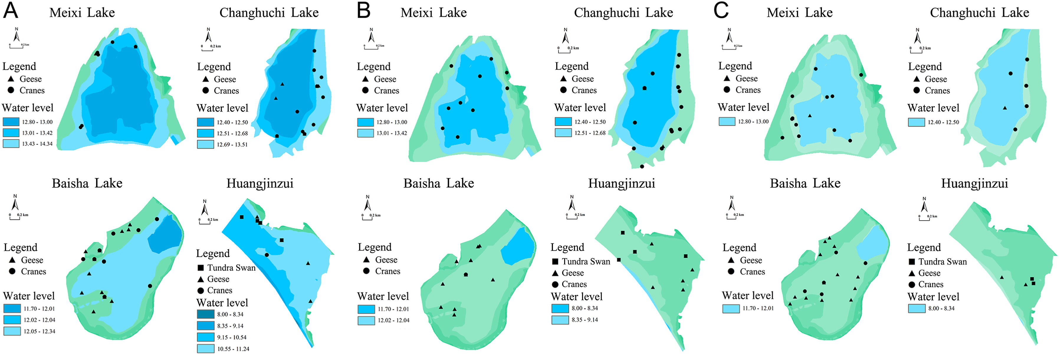
In 2016, the land–water transition zone for waterbirds was smaller in the early part of the wintering period (October–November), and the waterbirds were mainly distributed in the lakeshore with higher terrain of three shallow sub-lakes (Fig. 4A). In the middle wintering period (December–January), the water level declined slowly and geese stayed in the original vegetation zone of the lakeshore. The cranes moved toward the center of the lake (Fig. 4B), which was evident in Meixi Lake. In contrast, almost no water was seen in Huangjinzui of main lake area where the water level dropped suddenly, with geese predominating and no obvious trend in distribution. During the late wintering period (February–March), both geese and cranes moved toward the center of the shallow sub-lakes, while the distribution of waterbirds decreased significantly in the main lake but with no clear distribution regularity (Fig. 4C).
Figure
4.
Distribution of waterbirds as water levels decline during the overwintering period. (A) middle November; (B) early January; (C) middle February.
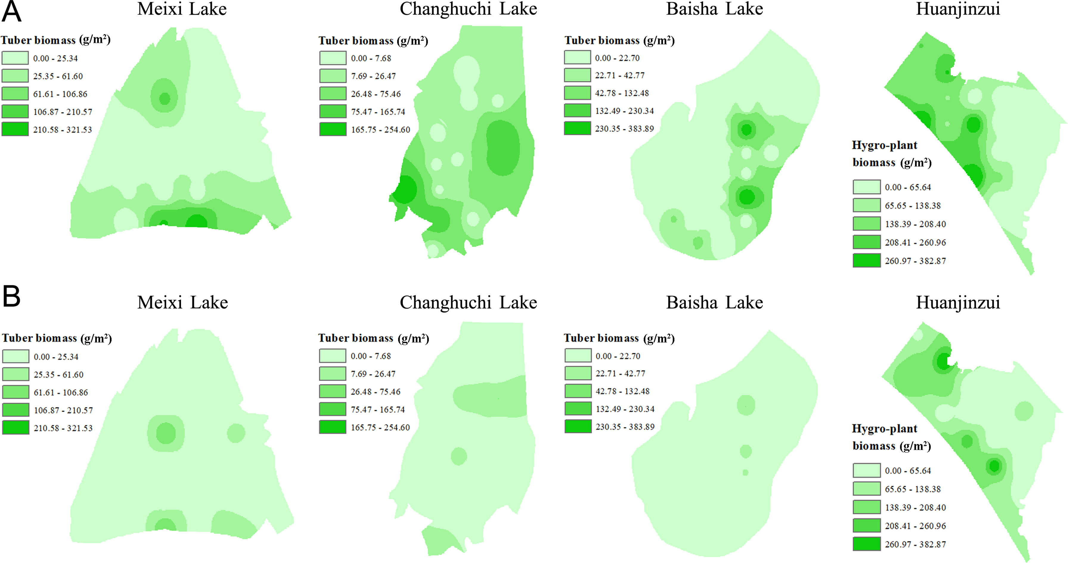
The dominant submerged plant type in Meixi Lake, Changhuchi Lake, and Baisha Lake was the tuber, which accounted for 98.43% of the total submerged plant biomass in 2016. Tubers were mainly distributed in the mudflats and shallow water areas in the dry season and were rarely distributed in the main lake. Almost no typical submerged plants were found in Huangjinzui, and the dominant plant was P. hydropiper, which accounted for 99.93% of all wet plant biomass.
The model results (Fig. 5) calculated using IDW for tubers (wet weight) showed that they were mainly distributed in shallow water in the early wintering period in 2016, with fewer in deeper water in the lake center (almost a circular pattern). In Meixi Lake, the average density of tubers was 43.65 g/m2 before wintering and 16.09 g/m2 after wintering. The average density of tubers in Changhuchi Lake was 42.40 g/m2 before wintering and 5.54 g/m2 after wintering. The average density of tubers in Baisha Lake was 26.69 g/m2 before wintering and 6.71 g/m2 after wintering. In Huangjinzui, however, the distribution of biomass was random because it was dominated by P. hydropiper, with the average density being 138.87 g/m2 before wintering and 99.53 g/m2 after wintering.
Figure
5.
Distribution of tubers in early (A; middle October of 2016) and late (B; middle March of 2017) wintering period.
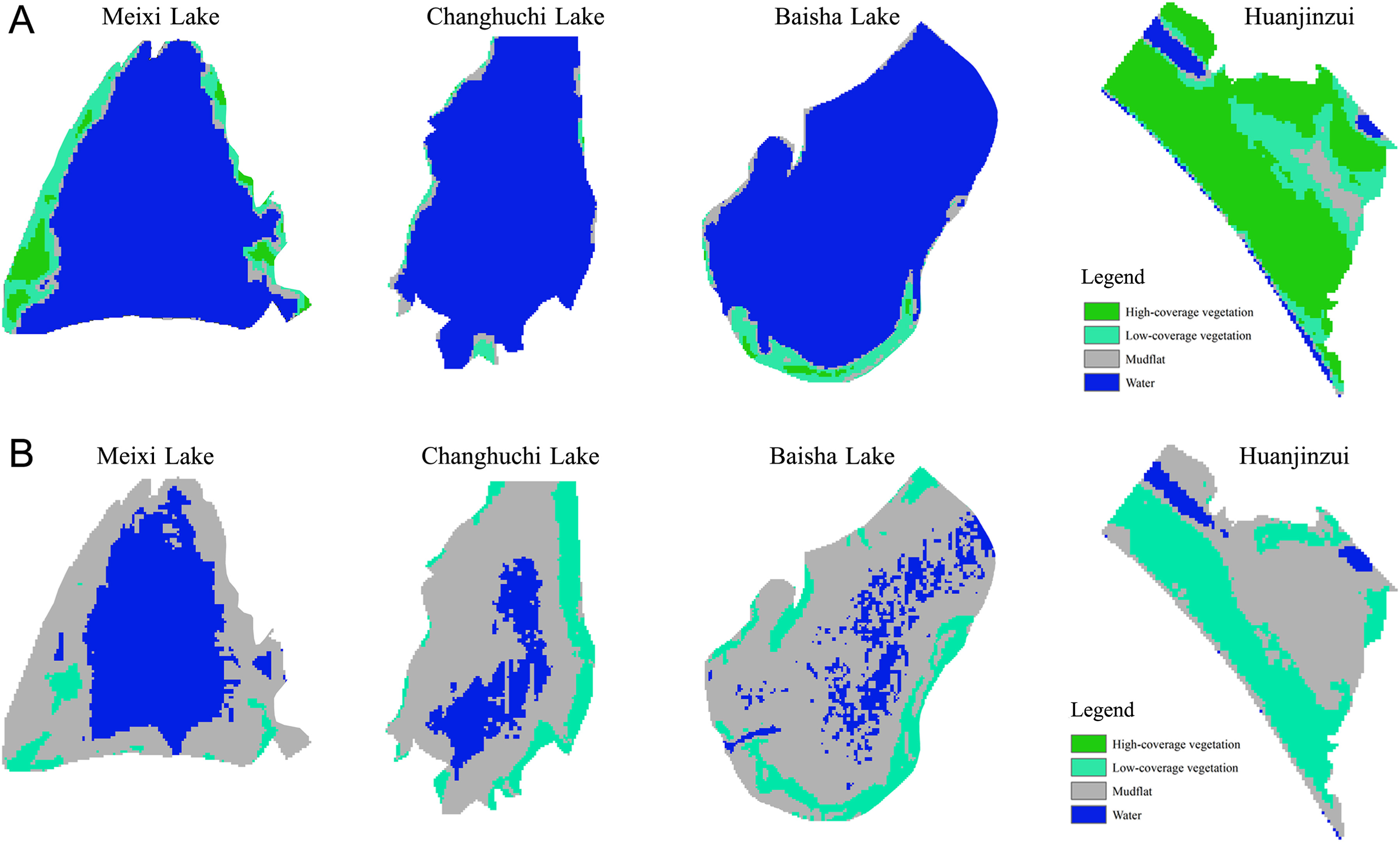
The results of the lakeshore vegetation survey showed that the dominant plant was Carex spp. in the shallow sub-lakes. The Carex spp. were mainly distributed in the relatively high terrain of the lake, in a circular pattern surrounding the mudflats and low waters. In 2016, the distribution of lakeshore vegetation in early wintering period (Fig. 6A) indicated that the shallow sub-lakes were mostly covered with water, but the edges were dominated by Carex spp. Almost no water was seen in Huangjinzui, which was covered by P. hydropiper. In the late wintering period, the area of the shallow sub-lakes decreased, the area of the mudflats increased, and Carex spp. extended toward the center of the lake. Carex spp. dominated in the late wintering period of foraging. Huangjinzui was still occupied by P. hydropiper but some mudflats were found (Fig. 6B). The total biomass of tubers (dry weight) was estimated to be 3.59 × 10³ t in the shallow sub-lakes in the early wintering period. This implied that Poyang Lake could support up to ca. 162, 000 cranes and Tundra Swans for the whole wintering period (Appendix Table S1).
Figure
6.
Distribution map of lakeshore vegetation in early (A; November 3, 2016) and late (B; February 26, 2017) wintering period (NDVI map).
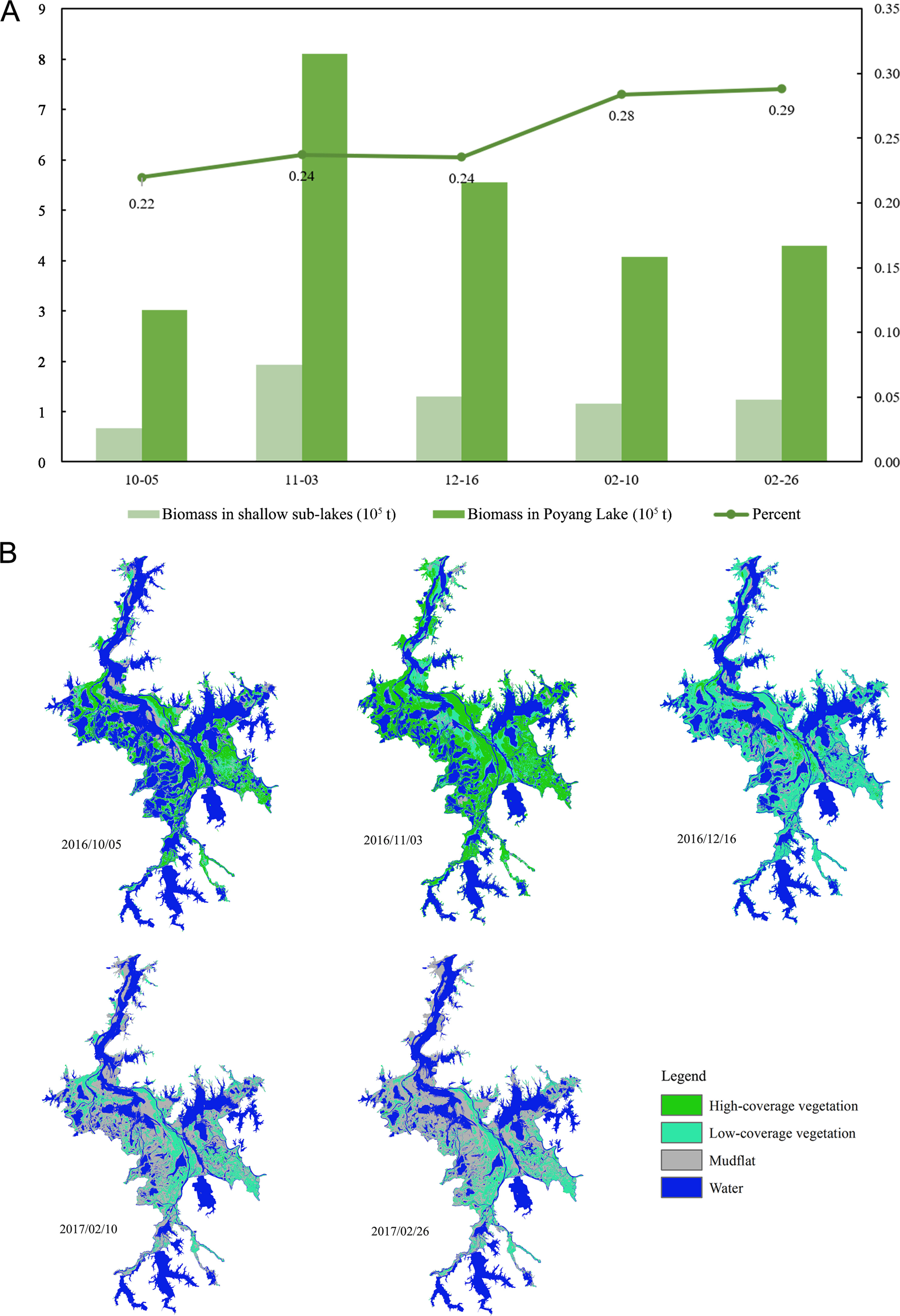
The results of the biomass changes during the wintering period (Fig. 7) suggested that the biomass of Carex spp. was relatively limited in Poyang Lake in early October. Carex spp. started to grow from October to November, and the biomass peaked in November and then began to decline in December. Therefore, the biomass of Carex spp. in November was considered as the available energy for geese. The total biomass of Carex spp. was estimated to be 1.92 × 10⁵ t, which could support a maximum of 1.53 × 10⁶ geese. For all of Poyang Lake, the total biomass could reach 8.1 × 10⁵ t in early wintering, supporting 6.79–9.71 × 10⁶ geese (Appendix Table S2).
Figure
7.
(A) The specific values of the lakeshore vegetation biomass of shallow sub-lakes and Poyang Lake, and the proportion in wintering periods; (B) Distribution map of lakeshore vegetation biomass in Poyang Lake in wintering periods (NDVI map).
4.1
Rich food resources are essential for wintering waterbirds
The shallow sub-lakes have better habitat conditions than other areas and can provide more adequate food resources for herbivorous waterbirds (Xia et al., 2021). Deep water, prolonged inundation, or droughts can harm wetland vegetation communities, thus threatening the foraging of wintering waterbirds (Holm and Clausen, 2006; Wang et al., 2019; Li et al., 2019b). For example, cranes and Tundra Swans mostly forage tubers in mudflats and shallow water (Barzen et al., 2009). Water depth and duration of inundation determine the biomass of tubers because light is crucial for tuber growth and water depth can affect light and transparency (Chen et al., 2020). Abnormally high floods in 2010 resulted in the lack of tubers, leading to significant habitat switches and diet shifts in herbivorous waterbirds (Burnham et al., 2017). In the wet season, shallow sub-lakes were connected to Poyang Lake and had the same water level, but the water depth was different from that in the main lake area in the dry season (Hu et al., 2015). The structure of the Poyang Lake basin resulted in sediment deposition over time, forming a high depression on both sides of the main lake area. Addtionally, fishers created small depressions to form one shallow sub-lake after another. This led to sub-lakes having water depths lower than that of the main lake. The tubers were mainly distributed in the shallow sub-lakes. As a result, the shallow sub-lakes supported essentially all the cranes and Tundra Swans.
The study of geese habitat by Xia et al. (2010) showed that the foraging area of shallow sub-lakes was almost twice as large as other areas, with 66.95% of the geese concentrated in shallow sub-lakes. For wintering geese in Poyang Lake, Carex spp. serve as a major food source for wintering geese in Poyang Lake (Zhang et al., 2011; Li et al., 2019b). In October and November, fresh Carex spp. grow with the decline in the water level. However, the main lake area cannot provide sufficient food for the geese, and most of the area is covered with P. hydropiper with receding water. P. hydropiper can be used as an alternative food for geese but only as an emergency measure to cope with poor conditions, and it is not normally eaten in large quantities.
4.2
The sustainable food in shallow sub-lakes maintains waterbirds
A gradually declining water level is more advantageous than a rapidly declining one. This allows for the continuous exposure of new lakeshore over a longer period, providing a continuous supply of food and habitat for waterbirds (Li et al., 2019b; Hu et al., 2015). Human-controlled shallow sub-lakes perfectly fit this purpose. Because of anthropogenic management, the water level of shallow sub-lakes slowly recedes and a submerged plant zone dominated by tubers is exposed (Fig. 5). The suitable water depth allows the concentration of waterbirds, such as cranes and Tundra Swans, to be concentrated there for foraging, following the emergence of tubers toward the center of the lake (Fig. 4; Appendix Fig. S5). Carex spp. also grows as the water level declines in October and November. The proportion of shallow sub-lakes to the total biomass of Carex spp. in the Poyang Lake has increased, and amajority of geese feed on fresh Carex spp. in shallow sub-lakes. At the same time, the gradually declining water level delays the decline in the biomass of Carex spp., which ensures that herbivorous waterbirds can make full use of it for successful wintering (Yu et al., 2015; Singh and Sinha, 2019).
In contrast, the rapid receding of the water level can lead to dry conditions and soil hardness in the main lake (Hassall et al., 2001). Therefore, premature exposure is not beneficial for herbivorous waterbirds because it requires more effort to pick tubers from the dried soil (Wang et al., 2013a, b). The gathering of geese is seen in early wintering period, but subsequent drying out causes P. hydropiper to dry out. Sequentially rising and falling water levels also decrease habitat quality for geese.
In conclusion, shallow sub-lakes with slowly declining water levels provide adequate and available food for wintering waterbirds. More than 80% of the total wintering waterbirds in Poyang Lake are distributed in the shallow sub-lakes each year (Hu et al., 2015). Shallow sub-lakes provide a different wetland environment from the main lake and play a transitional and buffering role during the changes in high and low water levels (Yamazaki et al., 2011; Gownaris et al., 2018). As the water level recedes, the shallow sub-lakes provide food resources and habitat. It is the shallow sub-lakes that allow hundreds of thousands of wintering waterbirds to stay in Poyang Lake for half of the year, contributing significantly to the year-round stability of successful wintering (Sullivan et al., 2009; Hou et al., 2020).
4.3
Existing issues and recommendations
In recent years, water level fluctuations of Poyang Lake have been extremely variable interannually, leading to changes in vegetation distribution (Lin et al., 2023). The water level is repeatedly recorded as low, so the expansion of Carex spp. has contributed to the increase of in the geese population (Xia et al., 2021). Moreover, the excessive decline of the water level in Poyang Lake enhances the soil hardness, inevitably affecting the carrying capacity of the lake. Conversely, high water levels in the wet season cause a reduction in tubers, resulting in the movement of tuber-eating waterbirds to the peripheral areas of Poyang Lake (Zou et al., 2021). At present, shallow sub-lakes can mitigate negative impacts to a certain extent.
We recommend that anthropogenic management in shallow sub-lakes should be refined. Many lakes are unmanaged, and hence wintering waterbirds cannot make full use of submerged and lakeshore vegetation. It is suggested that the authorities should make a unified plan for managing shallow sub-lakes, and regulate the water level in a standardized way to provide continuous habitat for wintering waterbirds. Fishing is forbidden during the annual release of water before the Chinese Spring Festival. Therefore, the water should be gradually released until the end of March of the next year. This can allow waterbirds to make full use of the habitat for foraging, ensuring the successful wintering of migrating waterbirds.
Ethics statement
We obtained approval from the reserve management office before carrying out the experiment.
CRediT authorship contribution statement
Mengjie Lu: Data curation, Formal analysis, Methodology, Writing – original draft, Visualization. Zhen Zhang: Data curation, Investigation, Methodology. Peng Chen: Data curation, Investigation. Changxin Xu: Data curation, Investigation. Bin Gao: Investigation, Visualization. Luzhang Ruan: Conceptualization, Supervision, Writing – review & editing, Funding acquisition, Project administration.
Declaration of competing interest
The authors declare that they have no known competing financial interests or personal relationships that could have appeared to influence the work reported in this paper.
Barter, M., Cao, L., Chen, L., Lei, G., 2005. Results of a survey for waterbirds in the lower Yangtze floodplain, China, in January-February 2004. Forktail 21, 1-7.
Barzen, B.J., Engels, M., James, B., Harris, J., Wu, G., 2009. Potential impacts of a water
control structure on the amount and distribution of wintering waterbirds at Poyang
Lake. Poyang Lake Assessment. International Crane Foundation, Baraboo, pp. 8–28.
Baschuk, M.S., Koper, N., Wrubleski, D.A., Goldsborough, G., 2012. Effects of water depth, cover and food resources on habitat use of marsh birds and waterfowl in boreal wetlands of Manitoba, Canada. Waterbirds 35, 44-55. .
Burnham, J., Barzen, J., Pidgeon, A.M., Sun, B., Wu, J., Liu, G., et al., 2017. Novel foraging by wintering Siberian Cranes at China's Poyang Lake indicates broader changes in the ecosystem and raises new challenges for a critically endangered species. Bird. Conserv. Int. 27, 204-223. .
Chen, L.G., Chen, L.M., Xu, Y.F., Luan, Z.Y., Jin, Q., Shi, Y., et al., 2020. Effects of water level fluctuation on the potential habitat area of Vallisneria natans in Poyang Lake. Water Sci. Adv. 31, 377-384. .
Delany, S., 2005. Guidelines for Participants in the International Waterbird Census
(IWC). Wetlands International, Wageningen.
Doyle, R.D., Smart, R.M., 2001. Effects of drawdowns and dessication on tubers of hydrilla, an exotic aquatic weed. Weed Sci. 49, 135-140.
Feng, L., Hu, C., Chen, X., Cai, X., Tian, L., Gan, W., 2012. Assessment of inundation changes of Poyang Lake using MODIS observation between 2000 and 2010. Remote Sens. Environ. 121, 80-92. .
Fuller, D.O., Wang, Y., 2014. Recent trends in satellite vegetation index observations indicate decreasing vegetation biomass in the southeastern saline everglades wetlands. Wetlands 34, 67-77.
González-Gajardo, A., Sepúlveda, P.V., Schlatter, R., 2009. Waterbird assemblages and habitat characteristics in wetlands: influence of temporal variability on species-habitat relationships. Waterbirds 32, 225-233. .
Gownaris, N.J., Rountos, K.J., Kaufman, L., Kolding, J., Lwiza, K.M.M., Pikitch, E.K., 2018. Water level fluctuations and the ecosystem functioning of lakes. J. Great Lake. Res. 44, 1154-1163. .
Hassall, M., Riddington, R., Helden, A., 2001. Foraging behaviour of brent geese, Branta b. bernicla, on grasslands: effects of sward length and nitrogen content. Oecologia 127, 97-104. .
Holm, T.E., Clausen, P., 2006. Effects of water level management on autumn staging waterbird and macrophyte diversity in three Danish coastal lagoons. Biodivers. Conserv. 15, 4399-4423. .
Hou, J., Liu, Y., Fraser, J.D., Li, L., Zhao, B., Lan, Z., et al., 2020. Drivers of a habitat shift by critically endangered Siberian cranes: evidence from long-term data. Ecol. Evol. 10, 11055-11068. .
Hu, Z.P., Zhang, Z.F., Liu, Y.Z., Ji, W.T., Ge, G., 2015. The function and significance of the Shallow-Lakes in the Poyang Lake wetland ecosystem. Jiangxi Hydraul. Sci. Technol. 41, 317-323 (in Chinese).
Jeffrey, L.B., Peek, J.M., Strand, E.K., 2009. Estimates of elk summer range nutritional carrying capacity constrained by probabilities of habitat selection. J. Wildl. Manag. 70, 283-294. .
Jia, Y., Jiao, S., Zhang, Y., Zhou, Y., Lei, G., Liu, G., 2013. Diet shift and its impact on foraging behavior of Siberian crane (Grus leucogeranus) in Poyang Lake. PLoS One 8, e65843. .
Jiang, F., Qi, S., Liao, F., Ding, M., Wang, Y., 2014. Vulnerability of Siberian crane habitat to water level in Poyang Lake wetland, China. GISci. Rem. Sen. 51, 662-676. .
Kirby, J.S., Stattersfield, A.J., Butchart, S.H.M., Evans, M.I., Newton, I., 2008. Key conservation issues for migratory land- and waterbird species on the world's major flyways. Bird. Conserv. Int. 18, S49-S73. .
Klein, E., Berg, E.E., Dial, R., 2005. Wetland drying and succession across the kenai peninsula lowlands, southcentral Alaska. Can. J. For. Res. 35, 1931-1941. .
Klemas, V., 2013. Remote sensing of coastal wetland biomass: an overview. J. Coast Res. 29, 1016-1028.
Li, C., Yang, Y., Wang, Z., Yang, L., Zhang, D., Zhou, L., 2018. The relationship between seasonal water level fluctuation and habitat availability for wintering waterbirds at Shengjin lake, China. Bird Conserv. Int. 29, 100-114. .
Li, L., Zhang X., Qin, H., Hu, X., Chen, J., 2015. Effects of tuber-feeding waterbird guild and water level fluctuation on tuber distribution of submerged macrophytes in Shahu Lake. Chin. J. Ecol. 34, 661-669.
Li, Y., Qian, F., Silbernagel, J., Larson, H., 2019a. Community structure, amount variation and population trends of waterbirds in relation to water level fluctuation in Poyang Lake. J. Great Lake. Res. 45, 976-985. .
Li, Y., Zhang, Q., Cai, Y., Tan, Z., Wu, H., Liu, X., et al., 2019b. Hydrodynamic investigation of surface hydrological connectivity and its effects on the water quality of seasonal lakes: insights from a complex floodplain setting (Poyang Lake, China). Sci. Total Environ. 660, 245-259. .
Lin, Y., Li, X., Tan, Z., Song, Y., Xu, C., 2023. Dynamic changes of plant communities in flooded wetlands of Poyang Lake based on spatiotemporal fusion of remote sensing. J. Lake Sci. 35, 1408-1423. (in Chinese).
Liu, H., Yuan, H., Wang, S., Zheng, L., Liao, M., 2021. Spatiotemporal dynamics of water body changes and their influencing factors in the seasonal lakes of the Poyang Lake region. Water 13, 1539. .
Mackinnon, J., Phillipps, K., 2000. A Field Guide to the Birds of China. Hunan Education
Press, Changsha.
Maia, P.D., Maurice, L., Tessier, E., Amouroux, D., Cossa, D., Moreira-Turcq, P., et al., 2018. Role of the floodplain lakes in the methylmercury distribution and exchanges with the Amazon River, Brazil. J. Environ. Sci. 68, 24-40. .
McCall, T.C., Bender, L.C., 1997. Comparison of techniques for determining the nutrional carrying capacity for white-tailed deer. J. Range Manag. 50, 33-38.
Mei, X., Dai, Z., Fagherazzi, S., Chen, J., 2016. Dramatic variations in emergent wetland area in China's largest freshwater lake, Poyang Lake. Adv. Water Resour. 96, 1-10. .
Meng, Z.J., 2018. Study on the Model of Wintering Geese Habitats and Carrying Capacity
in Poyang Lake. Master's Thesis. Nanchang University, Nanchang (in Chinese).
Newton, I., 2008. The Migration Ecology of Birds. Academic Press, London.
Norris, D.R., 2005. Carry-over effects and habitat quality in migratory populations. Oikos 109, 178-186.
Robinson, V., Pizo, M.A., 2017. A floodplain with artificially reversed flood pulse is important for migratory and rare bird species. Rev. Bras. Ornitol. 25, 155-168. .
Singh, M., Sinha, R., 2019. Evaluating dynamic hydrological connectivity of a floodplain wetland in North Bihar, India using geostatistical methods. Sci. Total Environ. 651, 2473-2488. .
Sullivan, B.L., Wood, C.L., Iliff, M.J., Bonney, R.E., Fink, D., Kelling, S., 2009. eBird: a citizen-based bird observation network in the biological sciences. Biol. Conserv. 142, 2282-2292.
Tan, Z., Li, Y., Xu, X., Yao, J., Zhang, Q., 2019. Mapping inundation dynamics in a heterogeneous floodplain: insights from integrating observations and modeling approach. J. Hydrol. 572, 148-159. .
van Eerden, M.R., Lenselink, G., Zijlstra, M., 2010. Long-term changes in wetland area and composition in The Netherlands affecting the carrying capacity for wintering waterbirds. Ardea 98, 265-282. .
van Geest, J.G., Coops, H., Roijackers, M.M.R., Buijse, D.A., Scheffer, M., 2005. Succession of aquatic vegetation driven by reduced water-level fluctuations in floodplain lakes. J. Appl. Ecol. 42, 251-260. .
Wan, W.J., 2016. Carrying Capacity Analysis of Wintering Hooded Crane (Grus monacha)
at Shengjin Lake. Master's Thesis. Anhui University, Hefei (in Chinese).
Wang, X., Fox, A.D., Cong, P.H., Cao, L., 2013. Food constraints explain the restricted distribution of wintering Lesser White-fronted Geese Anser erythropus in China. Ibis 155, 576-592. .
Wang, W., Fraser, J.D., Chen, J., 2017. Wintering waterbirds in the middle and lower Yangtze River floodplain: changes in amount and distribution. Bird. Conserv. Int. 27, 167-186. .
Wang, W.J., Fraser, J.D., Chen, J.K., 2019. Distribution and long-term population trends of wintering waterbirds in Poyang Lake, China. Wetlands 39, 125-135. .
Wang, Y., Jia, Y., Guan, L., Lu, C., Lei, G., Wen, L., et al., 2013. Optimising hydrological conditions to sustain wintering waterbird populations in Poyang Lake National Natural Reserve: implications for dam operations. Freshw. Biol. 58, 2366-2379. .
Wang, X., Xu, J., 2016. Collection of Wetland Plants in Poyang Lake. Science Press,
Beijing.
Wilcove, D.S., Wikelski, M., 2008. Going, going, done: is animal migration disappearing. PLoS Biol. 6, e188. .
Xia, S.X., Yu, D., Cui, P., Duan, H., Teng, J., Yu, X.B., 2021. Suitable-habitat dynamics for wintering geese in China's largest freshwater lake. Global Ecol. Conserv. 27, e01528. .
Xia, S.X., Yu, X.B., Fan, N., 2010. The wintering habitats of migrant birds and their relationship with water level in Poyang Lake, China. Resour. Sci. 32, 2072-2078. . (in Chinese).
Xu, F., 2021. Environmental Mechanisms Underlying the Seasonal Migration Phenology
of East Asian Waterfowl. Doctoral Thesis. Tsinghua University, Beijing. .
Yamazaki, D., Kanae, S., Kim, H., Oki, T., 2011. A physically-based description of floodplain inundation dynamics in a global river routing model. Water Resour. 47, w04501. .
Yu, X., Hawley-Howard, J., Pitt, A.L., Wang, J., Baldwin, R.F., Chow, A.T., 2015. Water quality of small seasonal wetlands in the Piedmont ecoregion, South Carolina, USA: effects of land use and hydrological connectivity. Water Res. 73, 98-108. .
Yuan, L.Y., Li, W., 2008. Effects of water depths and substrate types on the distribution in winter buds of Vallisneria spinulosa in Poyang Lake. J. Yangtze Univ. Nat. Sci. 5, 55-58.
Yuan, L.Y., Li, W., Liu, G.H., Deng, G., 2012. Effects of different shaded conditions and water depths on the growth and reproductive strategy of Vallisneria spinulosa. Pakistan J. Bot. 44, 911-918.
Zhang, Q., Ye, X.C., Werner, A.D., Li, Y.L., Yao, J., Li, X.H., et al., 2014b. An investigation of enhanced recessions in Poyang Lake: comparison of Yangtze River and local catchment impacts. J. Hydrol. 517, 425-434. .
Zhang, S.D., Ma, Z.J., Choi, C.Y., Peng, H.B., Bai, Q.Q., Liu, W.L., et al., 2018. Persistent use of a shorebird staging site in the Yellow Sea despite severe declines in food resources implies a lack of alternatives. Bird. Conserv. Int. 28, 534-548. .
Zhang, X.C., Jin, B.S., Chen, J.K., Wu, J.D., Liu, G.H., Ma, Z.J., 2014a. Relationship between habitat use of four waterbird species and water depth and food resource in Poyang Lake. Chin. J. Zool. 49, 657-665. (in Chinese) .
Zhang, Y., Cao, L., Barter, M., Fox, A.D., Zhao, M.J., Meng, F.J., et al., 2011. Changing distribution and abundance of Swan Goose Anser cygnoides in the Yangtze River floodplain: the likely loss of a very important wintering site. Bird Convers. Int. 21, 36-48. .
Zhu, Q., Zhan, Y., Liu, G., Wu, J., Zhan, H., Huang, Y., et al., 2012. Investigation of number and distribution of the waterfowl of Poyang Lake in the winter of 2011. Jiangxi Forest. Sci. 3, 1-9. (in Chinese) .
Zou, L., Hu, B.S., Qi, S.H., Zhang, Q.Q., Ning, P., 2021. Spatiotemporal variation of Siberian crane habitats and the response to water level in Poyang Lake wetland, China. Rem. Sens. 13, 140. .

 DownLoad:


 Email Alerts
 RSS Feeds