Research Institute of Forest Ecology, Environment and Protection, Key Laboratory of Forest Protection of the State Forestry Administration, Chinese Academy of Forestry, Beijing 100091, China
2.
Northeast Institute of Geography and Agricultural Ecology, Chinese Academy of Sciences, Changchun 130012, China
3.
College of Wildlife Resources, Northeast Forestry University, Harbin 150040, China
In order to measure the impact of changes in the marsh on breeding Red-crowned Cranes (Grus japonensis) and White-naped Cranes (G. vipio) in the Sanjiang Plain, we conducted a complete crane survey in each of the summers of 2007 and 2008, and obtained information on the changes in its marsh through interpretation of satellite images in 1986, 1995, 2000 and 2005. A comparison between the 1984 and 2008 census shows that: 1) the number of Red-crowned Cranes remained stable at about 300 birds, while the number of White-naped Cranes increased markedly; 2) the estimates of nests of Red-crowned cranes are close to the numbers of 1984, while approximately 90% of the nests of these two crane species were distributed over five national nature reserves (NNRs); 3) the two crane species became more concentrated in three regions, i.e., the Fuyuan Delta, the middle reaches of the Naoli and Qixing rivers, and the Xingkai Lake wetlands, rather as formerly in six regions. The area of the marsh decreased by 45% within the 20-year period from 1986 to 2005. The major loss of the marsh area was in the form of a conversion to paddy fields and dry land, which can be primarily attributed to direct human activity under various economic and policy drivers. The disappearance of cranes in the Dulu and Abuqin rivers was induced by large-scale agricultural development. The fragmentation into and isolation of small areas of the marsh became increasingly more serious, which resulted in unsuitable condtions for crane breeding in small patches of the marsh. The number of cranes declined from 1984-1995 but had recovered remarkably by 2008, which may be due to the establishment of a system of nature reserves, in place since 2000. The land ownership of the reserve plays a key role in maintaining the integrity of the wetland ecosystem, especially in Sanjiang, Honghe, Naolihe and Qixinghe NNRs, which together accommodated approximately 80% of the population of cranes. However, we did not discover any nests at all in the provincial and municipal reserves, which may be attributed to high human disturbances in these areas. In the end, we propose some recommendations on reserve management.
Habitat destruction is the most significant cause in the decline and extinction of populations and species of animals and plants (Hanski, 1998; Prugh et al., 2008). Among birds, habitat destruction has been identified as the main threat faced by 82% of endangered species throughout the world (Temple, 1986). Habitat loss may occur in several ways, such as clearance of habitat, fragmentation of habitat into patches and decrease in the quality of habitats (Hanski, 1998). While impacts of habitat clearance are usually immediate and clearly identifiable, the ability of animals to persist in fragmented landscapes shows a great deal of interspecific variation and is dependent on their biological attributes. The abundance of some species does not change; some species flocks may increase in size, whereas most species either decline in number, forming fragmented distributions throughout their former ranges, or become extinct (Noss and Murphy, 1995; Schmidt and Roland, 2006; Swift et al., 2010).
The Red-crowned Crane (Grus japonensis) is the second most of rare crane species, with a total population of 2750 birds in the wild (BirdLife International, 2012). A migratory population of about 1550 birds breeds in southeastern Russia, northeastern China and Mongolia (Wang, 2008). The White-napped Crane (G. vipio) is recognized as a vulnerable species in the IUCN Red List, with a total population estimate at 5500–6500 birds (BirdLife International, 2012). This species breeds in the northeast of Mongolia and China and adjacent areas of southeastern Russia (Hilton-Taylor, 2000; BirdLife International, 2012). For these two crane species, the key threat is the loss and degradation of wetlands in their breeding and wintering grounds, principally to conversion for agricultural purposes and growing human demand for water, but also on account of industrial and economic development (Masatomi et al., 1990; Harris, 1994; Smirenski et al., 1995; Bradter et al., 2007; Lee et al., 2007; Wang, 2008; Jiang et al., 2009; Su and Wang, 2010). All of these causes resulted in a decline of the Red-crowned Crane and as well as the probable decline in the number of White-naped Cranes (BirdLife International, 2012).
The Sanjiang Plain, located in the Heilongjiang Province of northeastern China, is the largest freshwater marsh in China (Liu, 1997). It is one of the most important breeding grounds for the Red-crowned and White-naped cranes in the world (Liu and Ma, 2002; BirdLife International, 2012). Historically, only one complete survey on the number and distribution of breeding cranes was ever conducted, in this case in May of 1984, with a Y-11 light airplane. A total of 309 Red-crowned Cranes (Ma and Jin, 1987) and only 11 White-naped Cranes (Feng and Li, 1985) were counted in that survey. In 1995, the second aerial survey largely focused on only part of the region when 65 Red-crowned Cranes were counted (Piao et al., 2000). For other surveys, again only part of the Sanjiang Plain was covered with the focus mainly on the Red-crowned Crane (Han et al., 2003; Li et al., 2003; Feng et al., 2005; Yang et al., 2005; Cheng and Li, 2006; Hua et al., 2006).
Since the end of the 1950s, large-scale development in the Sanjiang Plain marsh has occurred (Liu and Ma, 2002). By 2003, about 80% of natural wetlands had been reclaimed for agriculture and the loss of wetlands continues (Liu et al., 2004). According to Zhao (1999), if the marsh decreases at the same rate as in recent years, the natural marsh of the Sanjiang Plain will disappear within 20 years. In order to protect the existing marsh and biodiversity, including the cranes in the Sanjiang Plain, 18 nature reserves have been established since 2000 (Table 1). Our surveys dealt with two questions: 1) Has the large-scale agricultural development from 1986–2005 (20 years) in the Sanjiang Plain resulted in the decline of breeding cranes? 2) Is crane protection effective with the improvement in the system of nature reserves since the end of the last century?
Table
1.
Basic information on survey sites and related nature reserves in the Sanjiang Plain. The reserve information was provided by the Division of Wildlife Management, Heilongjiang Forestry Department, established before September, 2007.
20 Raohe Farmland, 21–22 Shengli Farmland, 23 Qiangpaizhan of Changling Island, 24 Luoma Lake, 25 Wuxing Lake, 26 Dayudui of Yanwo Island, 27 Pingyuan Reservoir of Yanwo Island, 28 Paotai of Yanwo Island, 29 Qiangpaizhan of Yanwo Island, 30 Tower of Changling Island, 31 Qiangpaizhan of Hongqiling
41 Zhenbao Island, 42 Liuguafupaozi, 43 Hutou, 44 Yueya Lake, 45 Bird Island
Xingkai Lake NNR
1994
222488
46–49 Northeast Paozi, 50–51 Longwangmiao
a MNR, municipal nature reserve; PNR, provincial nature reserve, NNR, national nature reserve; PS, protection station. The abbreviations also apply to Tables 2 and 3.
To address these two questions, we conducted ground surveys on breeding cranes in the summers of 2007 and 2008 and obtained information on the changes in the marsh through interpretation of satellite images in 1986, 1995, 2000 and 2005 of the Sanjiang Plain. Considering that the Red-crowned and White-naped cranes are large and white-colored species (Frederick et al., 1996; Rodgers et al., 2005), we assume the results of complete aerial and ground surveys are reliable and comparable, especially in the reed growing season and relatively flat marshes. Hence, we compared the number and distribution of the two crane species between the census of 1984 and that of 2008, explored the effect of changes in the marsh landscape on the distribution of cranes and breeding pairs on a regional scale and discuss the efficiency of the system of nature reserves on the protection of cranes. In the end, we propose several measures for the conservation of cranes and habitat management.
Study area
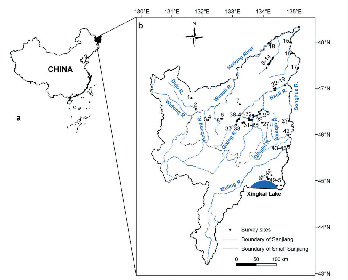
The Sanjiang Plain, covering a total area of 108900 km2, is located in the northeast of China (43°49′–48°27′N, 129°11′–135°05′E) (Fig. 1). The Sanjiang Plain was formed by a low alluvial plain of three rivers: the Heilong, Songhua and Wusuli rivers (Liu and Ma, 2002). The plain is divided into a northern and southern part by the Wanda Mountains. The core area of the northern part is referred to as the Small Sanjiang Plain with a total area of 45500 km2, and the southern part as the Mulin-Xingkai Plain with a total area of 8800 km2 (Liu and Ma, 2002) (Fig. 1a). Before the 1950s the Sanjiang Plain was still a pristine area. At the end of the 1950s, a great number of retired soldiers swarmed into this region to reclaim the wetland (also called the Sanjiang Plain marsh). Over the past 50 years, the area of cultivated land increased from 15.91% of the total area in 1954 to 48.16% by the year 2000, while the area of wetlands decreased from 32.74% in 1954 to 10.31% in 2000 for the entire Sanjiang Plain (Song et al., 2008). Of a total population of 7.8 million in the plain, 53.4% are engaged in farming. The plain has become one of the most important commercial grain baskets in China, with a total yield of grain and beans of about 704.25 million ton per year (Liu and Ma, 2002).
Figure
1.
Location of Sanjiang Plain in China (a) and distribution of survey sites of cranes (b) at Sanjiang Plain in the summer of 2007 and 2008
The climate of the study area is characterized as a temperate humid and sub-humid continental monsoon region. The average temperature is –18℃ in January and 21–22℃ in July. The frost-free period is 120–140 days. Annual precipitation is 500–650 mm, with 80% of the precipitation occurring from May to September. Most of the rivers in the area have riparian wetland characteristics — a slight gradient and a large channel curve coefficient. The types of plants present belong to the Changbai flora, largely meadow and marsh vegetation (Liu and Ma, 2002).
Methods
Field method
Referring to historical references in relation to population size and distribution of cranes in the Sanjiang Plain (Feng and Li, 1985; Ma and Jin, 1987; Li et al., 2003), together with the distribution range of marshes obtained from TM satellite images in 2005, we confirmed each and every potential distribution range of cranes in Sanjiang Plain. From 1–13 June 2007 and between 22 May and 3 June 2008, three survey teams simultaneously conducted complete ground surveys of the cranes at 51 sites (Fig. 1, Table 1) of the plain. The first team took charge of the Xingkai Lake wetland, the second team was responsible for the Qixing and Naoli rivers and the third team surveyed the Dulu River and Fuyuan Delta. For each survey site, we counted the number of cranes from the top of 20 to 30 m high towers or from two to four observation sites, using a 20 × 60 SWAROVSKI telescope. Each visit varied in time from 15 to 40 min, depending on the number of cranes present and the difficulty in estimating the number of nests or breeding pairs. One problem needs to be mentioned, i.e., the complete ground survey for the Naoli and Qixing rivers was conducted by only one team and the other two teams did not complete the entire survey due to weather problems in 2007.
Meanwhile, referring to publications of territorial research into Red-crowned and White-napped cranes (Zhou and Su, 1990; Li and Li, 1998; 1999), as well as consulting related crane experts, we defined cranes as a breeding pair according to one of the following criteria:
1) When a pair or a single crane moves around the nest, it was defined as a breeding pair;
2) When a surveyor approached the cranes to about 600 m and one crane still moved in the surroundings, it was defined as a breeding pair;
3) When a pair or a single crane observed in the marsh, whose area exceeded 2.6 km2 (for Red-crowned Crane) or 4.2 km2 (for White-naped Crane), the patch width wider than 1.5 km and without or with only a very few anthropogenic activities such as fishing and grazing, we defined it as a breeding pair;
4) When two pairs of cranes were observed in the marsh at a distance exceeding 600 m, and the area exceeded 5.0 km2 (for Red-crowned Crane) or 8.0 km2(for White-naped Crane), with the patch width wider than 1.5 km and again no or very few human activities, such as fishing and grazing, we defined them as two breeding pairs.
Land cover
Red-crowned Cranes prefer to nest and feed in a marsh with relatively shallow water, building their nests in areas with standing dead vegetation (Smirenski, 1988). A typical White-napped Crane breeding habitat includes shallow wetland and wet meadows in broad river valleys, along lake edges and in lowland or mixed forest steppes (Su et al., 1991; Fujita et al., 1994). We classified the land cover and land use of the Sanjian Plain into eight types: marsh, paddy field, dry land, forest (broad leaved trees and shrubs), grassland, mudflat (no vegetation in the edge of lakes and along rivers), residential area and open water (lakes, temporal and permanent water and rivers). Among these types, only the marsh was treated as a suitable habitat for breeding cranes.
The study area covered 12 Landsat TM/ETM scenes. The land cover types in the Sanjiang Plain were identified using the satellite images in 1986, 1995, 2000 and 2005. All images were obtained from June to September since this period is the growing season and best for land cover classification. All images had already been radio-metrically corrected when purchased and registered using the Gauss projection (identical to that of registered topographic maps) using the ERDAS Imagine 8.7 software.
The 12 scenes of images acquired in 2005 were used as reference images to correct the other 36 scenes (for image to image registration) in 1986, 1995 and 2000. An average error (RMS) of less than 0.5 m was achieved for all images, while the pixel size was kept at 30 m × 30 m. Our study area ran across all 12 scenes of the TM imagery. We performed a histogram matching between adjacent scenes for the same year using the ERDAS Imagine 8.7 software to conduct image-to-image radiometric normalization between adjacent images so that the distribution of brightness values within two adjacent images are as close as possible in the resultant mosaic image.
We used a combination of unsupervised and supervised classifications based on expert knowledge. More than 200 training locations were collected in the field for different land cover types in 2005. The accuracy of the resultant landscape maps was assessed using field survey reference data from the study area in 2005. Their error matrix indicated that the overall accuracy reached 87.5%.
Data processing
All vector data were converted to raster data on a 100 m × 100 m grid. We used the function of spatial analysis to generate a habitat transition matrix between different years. All spatial data were managed using ArcGIS 10.0.
We selected a set of eight indices such as those commonly used in landscape ecology studies, including number of patches (NP), patch density (PD), landscape shape index (LSI), area fragmentation index (FI) and edge density (ED). The algorithms and descriptions are in reference to those designed by Zhang et al. (2007). All indices except the FI were computed using Fragstats version 3.3 (McGarigal et al., 2002).
Results
Number and distribution of cranes
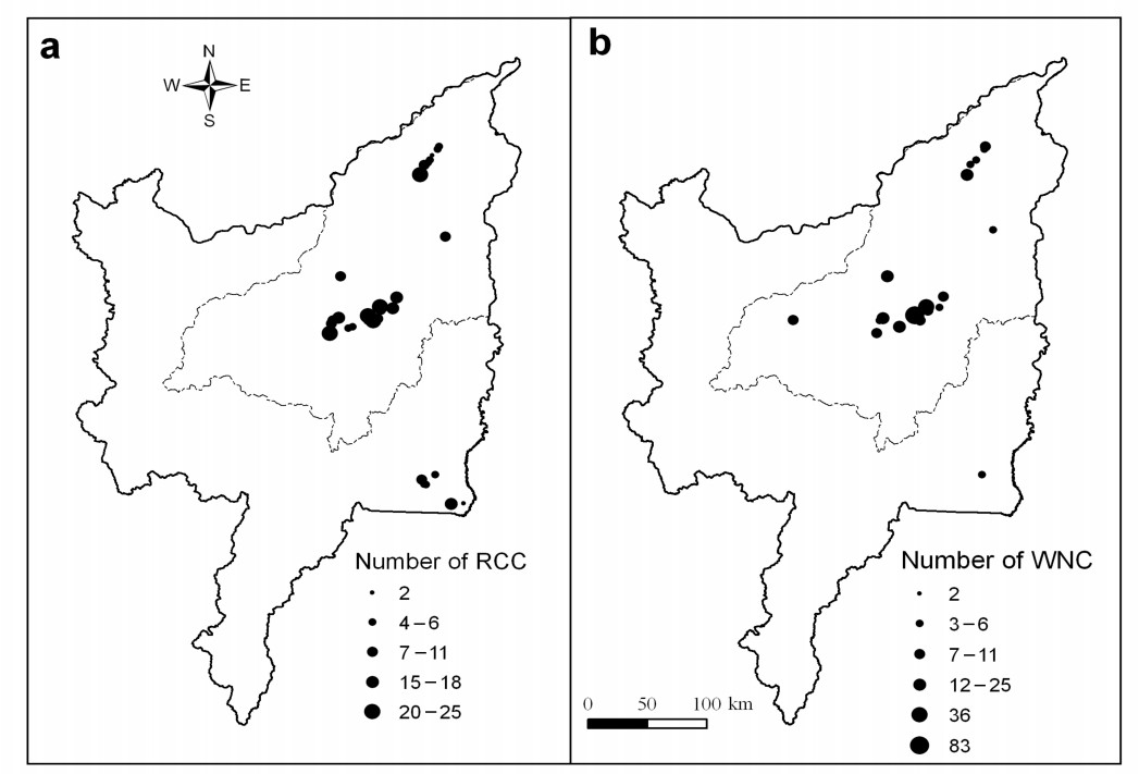
In 2007, 155 Red-crowned Cranes were counted, of which 54% stayed or moved as pairs; in 2008, we counted 303 cranes, 64% of which remained or moved as pairs (Table 2). The cranes were largely found in the marshes of the Fuyuan Delta (54 birds in 2008), Naoli and Qixing rivers (197 birds in 2008) and the Xingkai Lake wetlands (44 birds in 2008) (Fig. 2). The concentration area of the greatest number of cranes was located in the region of the Naoli and Qixing rivers, accounting for 65% of the total number of this crane in 2008.
Table
2.
Number and distribution of Red-crowned and White-naped cranes in Sanjiang Plain in the summer of 2007 and 2008. Blanks in the table mean the sites were not surveyed and the zero values mean the sites surveyed were without cranes.
Region
Reserve name
Site code
Red-crowned crane
White-naped crane
2007
2008
2007
2008
Anbang River
Anbanghe PNR
4
0
0
5 (2)
7 (3)
Wanyan River
Liuhetang MNR
7
0
8 (4)
0
19 (2)
Fuyuan Delta
Honghe NNR
8
4 (2)
20 (10)
2 (1)
14 (7)
9
6 (3)
10 (5)
0
6 (3)
10
1
4 (2)
0
0
Subtotal
11 (5)
34 (17)
2 (1)
20 (10)
Sanjiang NNR
11
6 (3)
4 (2)
12
2 (1)
0
13
6 (3)
6 (3)
14
4 (2)
9* (4)
16
0
2 (1)
0
2 (1)
Subtotal
0
20 (10)
0
21* (10)
Naoli River
Dajiahe PNR
19
0
7 (1)
0
0
Naolihe NNR
21
0
0
0
3
22
0
0
2
0
24
5
15 (3)
2
10
25
2 (1)
0
0
0
26
8 (4)
15
0
4
27
0
0
3* (1)
0
28
5 (2)
4 (2)
4 (2)
8** (2)
29
7 (1)
7 (1)
0
0
30
76 (20)
25 (6)
8 (3)
83
31
12 (2)
8 (4)
4
2 (1)
Subtotal
115 (30)
74 (16)
23*(6)
110**(3)
Dongsheng PNR
32
3
23 (4)
2
8
Qixing River
Qixinghe NNR
33
13 (3)
6 (2)
7 (2)
12 (2)
34
0
4
0
0
35
6 (1)
8 (3)
2 (1)
6 (2)
36
0
11
0
0
37
4 (2)
22 (4)
4
7 (1)
Subtotal
23 (6)
51 (9)
13 (3)
25 (5)
Sanhuanpao PNR
38
0
20 (3)
0
36 (3)
39
0
18 (9)
0
6 (3)
40
1
4 (2)
8
25
Subtotal
1
42 (14)
8
67 (6)
Xingkai Lake wetland
Xingkai Lake NNR
46
0
4 (2)
0
6 (3)
47
10 (5)
0
48
6 (3)
0
49
4 (2)
0
50
18 (9)
0
51
2 (1)
2 (1)
0
0
Subtotal
2 (1)
44 (22)
0
6 (3)
Total
155 (42)
303 (97)
53 (12)
283 (42)
* indicates the number of birds including one chick and ** indicates the number of birds including two chicks. The number in the bracket shows the number of pairs, which was counted during the survey.
Figure
2.
Population size and distribution of Red-crowned Crane (RCC) (a) and White-naped Crane (WNC) (b) at Sanjiang Plain in the summer of 2008. The grey line indicates the range of the Small Sanjiang Plain.
In 2007 we counted 53 White-naped Cranes and in the next year 282 (Table 2). Of these, only 23% stayed or moved away as pairs in 2007 and in 2008 this was only 15%. Distribution of the White-naped Crane was eerily similar to that of the Red-crowned Crane, except for the Xingkai Lake wetland (Fig. 2). Its greatest concentration was also in the region of the Naoli and Qixing rivers, accounting for 72% (202 cranes) of the total number of cranes in 2008.
The relatively large differences in the number of both crane populations are considerable between the two years. The major reason is that the survey was only conducted completely in the Naoli and Qixing river areas, but not in the Sanhuanpao and Dajiahe Provincial Nature Reserves (PNRs) due to the various factors, such as the climate in 2007. Actually, the number of Red-crowned cranes in this region was quite similar in the both years (138 birds in 2007 and 148 cranes in 2008). As well, both crane species frequently move in the border area of the Naolihe, Qixinghe and Sanhuanpao reserves.
Number and distribution of pairs of breeding cranes
According to the criteria defined in our field method, the number of breeding pairs of Red-crowned Cranes was 11 in 2007 and 43 in 2008 and those of the White-naped Crane 9 and 12 respectively (Table 3). The major difference between the both occurred at the Xingkai Lake NNR. Twenty-two breeding pairs of the Red-crowned Crane were estimated in 2008, while only one pair was inferred in 2007. For the White-naped Crane, three pairs were inferred in 2008, compared with no estimates for 2007.
Table
3.
Estimates of breeding pairs of Red-crowned and White-naped cranes based on defined criteria. The number in the bracket indicates the standard code we inferred as the breeding pair, which is in line with our study methods.
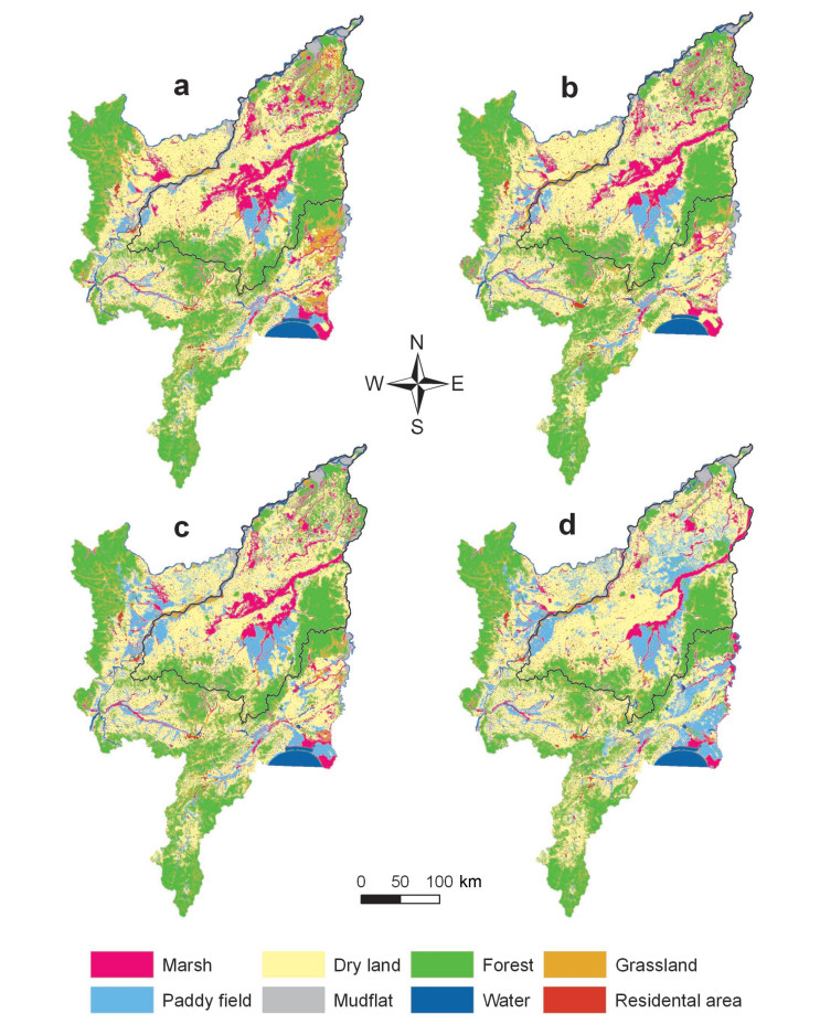
Over the study period, the area of all types of land cover, except for cultivated land, has decreased severely in the Sanjiang Plain between 1986 and 2005 (Table 4). During this period, the area of cultivated land increased by 14767 km2 (32.6%). However, this cover type increased by 7609 km2 from 2000 to 2005, approximately twice the rate from 1986 to 2000. The area of paddy fields increased approximately twice the area of dry land. The new paddy fields mainly expanded in the following four areas: the Dulu River, the Fuyuan Delta, the upper and middle reaches of the Naoli River and the Xingkai wetland (Fig. 3). The area of grassland and forest has decreased by over 4000 km2.
Table
4.
Changes of area (the number in the front of the bracket, km2) and area percentage (the number in the bracket) of seven land covers at different stages from 1986 to 2005 in Sanjiang Plain
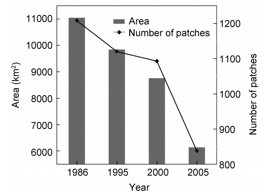
The original marsh has experienced a loss of approximately half of its area from 11044 km2 in 1986 to 6134 km2 in 2005, while the loss in the last five years is almost equal to the area lost in the earlier 15-year period between 1986 and 2000 (Table 4). This huge loss occurred in four areas: the Dulu River, the Fuyuan Delta, the Wai Qixing River and the Xingkai wetland (Fig. 3).
The loss of marsh mainly occurred through conversion to paddy fields accounting for 1637 km2 (14.8%) and to dry lands severing 4391 km2 (39.8%) between 1986 and 2005 (Table 5). The gain in marshes consisted largely from a conversion of grassland, forest and others (mudflat), but this increase was, by far, too small to compensate for the loss.
Table
5.
Changes in the area of marsh over four periods of varying length between 1986 and 2005. The extent of habitat loss or gain is expressed as percentage change of the area at the beginning of each period.
From 1986 to 2005, both the edge density and area fragmentation index of the marsh tended to increase, while the value of the landscape shape index showed a decline (Table 6). All three indicators suggest that fragmentation and isolation of the marsh have increased continuously during the last 20-year period. Accordingly, the number of marshes, as well as the mean and maximum patch areas shows a distinctively decreasing trend (Fig. 4). The rate of decline in the number of marsh patches, the mean and maximum patch areas, in the maximum patch perimeter and total perimeter length of the marshes from 1995 to 2005 was more than double than that in the 1986–1995 period. This is related to the development of the mechanization in agriculture after 1995, especially in the 21st century.
Table
6.
Dynamic changes of landscape indicators of the marsh in the Sanjiang Plain from 1986 to 2005
The number of Red-crowned cranes in 2008 (303 birds) was strikingly similar to the 309 cranes in 1984 (Ma and Jin, 1987), but no chicks was found and the crane distribution over the area changed enormously. The cranes became more concentrated in three regions: the Fuyuan Delta, the middle reaches of the Naoli and Qixing rivers and the Xingkai Lake wetlands, while the cranes were widely distributed in the six regions of the Sanjiang Plain in 1984. Three additional areas, where cranes are not found now, are the Dulu River and the lower reaches of the Naoli and Abuqin rivers (Ma and Jin, 1987).
The reed marshes of the Dulu River have for long periods been the concentration area for breeding Red-crowned Cranes (Feng and Li, 1985). A total of 23 cranes and four nests were recorded in 1984 (Ma and Jin, 1987). In the early 1990s, a water engineering project and agricultural development resulted in the loss and degradation of the marshes. By 2001, only six cranes were observed by Li et al. (2003). Since then, this crane has never used this area for breeding again (Cheng and Li, 2006). In the lower reaches of the Naoli River 16 Red-crowned Cranes were observed in 1984 and in the Abuqin River seven (Ma and Jin, 1987). These two regions are major areas for agriculture (Liu and Ma, 2002). Most of the land was converted to paddy fields and dry land, neither suitable for breeding by cranes.
For the Sanjiang NNR, about 47% (34276 ha) of the forest and almost all meadows were lost between 1986 and 2005. However, the marsh area remained stable (35504 ha in 1986 and 35852 ha in 2005) (Zhang et al., 2009). The number of Red-crowned cranes increased from four birds in 1984 to 20 in 2008. This may have been induced by the enormous loss of forests, increased visibility and security for breeding cranes. For the Honghe NNR, the suitable breeding habitats for the Red-crowned Crane increased from 1983 to 2005 (Liu and Li, 2008) with the number of cranes increasing from 28 in 1984 (Ma and Jin, 1987) to 34 in 2008. However, the connection between Honghe NNR and its surrounding farms declined to 70%, suggesting that the reserve has become an isolated island in the landscape and especially destroying the water balance between the reserve and its surrounding areas in a serious way (Liu and Li, 2008). The number of cranes in the Xingkai Lake NNR remained at about 50 birds, i.e., 52 in 1984 (Ma and Jin, 1987), 47 in 2003 (Feng et al., 2005) and 44 in 2008. Its hydrological condition is similar to that in the Honghe NNR. Due to the establishment of paddy fields, the marsh is faced with a water shortage and threatens to become a dry meadow (see Fig. 3). Therefore, while this crane in the three reserves is threatened by water shortage and a high level of human disturbance, the number of birds remains stable or may even be slightly increasing.
For the White-naped Crane in the Sanjiang Plain, it is the first time that such large numbers are reported in the summer. In the past, the maximum estimated number of cranes was 100–150, based on the earlier surveys (Cheng and Li, 2006). The number of cranes in the Naoli and Qixing rivers reached 202 birds in 2002. This number may be the result of some double counting, because the cranes moved continually among the surrounding sites of the Naolihe and Qixinghe NNRs and the Sanhuanpao Provincial Nature Reserve (PNR) (site codes 30, 33, 38, 39 and 40) (see Table 2 and Fig. 2). Even if we were to reduce this number because of some double counting, the total number in the Sanjiang Plain should be over 200 birds. However, the estimates of the number of nests is quite low, suggesting that most of the Sanjiang Plain is not suitable for breeding by this crane.
Factors determining current distribution of the two crane populations
The area of the marsh decreased by 45% within a 20-year period. The major loss was converted to paddy fields and dry land, especially during the last five years due to the mechanization of agriculture. Economics and policies were the major driving forces behind the changes in land use and cover in the Sanjiang Plain (Liu, 2000). Pursuing economic profit played a major role in transforming wetlands to cultivated land, explaining the inverse landscape dynamics between agriculture and changes in the area of the marsh (see Fig. 3). During the late 1970s to the early 1980s, the introduction of a system of family contracted responsibility led to massive wetland reclamation for agriculture. During the 1986–2000 period, the speed of agricultural development and wetland reclamation slowed due to increased cost of fertilizers, pesticides and seeds and lower crop prices. From 2000 to 2005, however, agricultural development and wetland reclamation was again promoted by government subsidies for agriculture.
As well, the population in the study area had increased 5.24 times from 1949 to 2005. The increase in cultivated land shows a high linear relationship with the increase in population (Song et al., 2008). Therefore, wetland loss in the Sanjiang Plain can be primarily attributed to direct human activity, mainly agricultural development.
The current marsh became fragmented and isolated in most areas of the Sanjiang Plain. Large marsh patches are now only found in three parts: i.e., the Fuyuan Delta, the middle reaches of the Naoli and Qixing rivers and the Xingkai Lake wetland (Fig. 3). These areas have the greatest concentration of the two crane species. For the middle reaches of Naoli and Qixing rivers, the number of Red-crowned cranes remained stable between 1984 and 2008. However, the estimate of nests (17 individuals) is considerably lower than the actual count of 197 cranes, which may be related to the high level of fragmentation and human disturbance. Fortunately, ownership of the two NNRs ensured the maintainance and stability of the wetland ecosystem. This region is still the major range for the two crane species, as long as the water situation can be controlled at a suitable level.
During the study period, the number of Red-crowned cranes remained stable while the number of White-naped cranes showed a marked increase. Actually, the number of Red-crowned cranes experienced a rapid decline from 176 in 1984 (Ma and Jin, 1987) to 50 in 1995 (Piao et al., 2000) in the middle reaches of the Qixing and Naoli rivers. The recently recovered population can be attributed to the establishment of the system, now in place, of nature reserves. As well, this increase may be contrasted to other distribution ranges of the two crane species which have fared far worse. For example, the Zhalong NNR has experienced serious water shortages and the occurrence of fires during the last ten years, which resulted in a considerable reduction in the number of Red-crowned cranes from 346 birds in 1996 (Pang, 2000) to the current level of about 200 (H.X. Jiang, unpublished data) and change in nest-site selection (Zou et al., 2003).
However, in most areas the cranes did not breed even where we counted 97 pairs of Red-crowned and 42 pairs of White-naped cranes in 2008. Estimates of the number of breeding pairs of the two species are considerably lower than the actual number of couples now present, suggesting that human disturbance is the major reason the cranes limit their breeding.
Management implications
In order to enhance the conservation of biodiversity and wetland management, seven NNRs with a total area of 6994 km2 and 13 PNRs with a total area of 3508 km2 were established in the Sanjiang Plain (Table 1). Our survey results show that all cranes are found in these reserves, which also is proof that this system of nature reserves has improved the efficiency of conservation. Approximate 90% of the nests of the two cranes at the national level are distributed in these reserves. This poses the question "why the cranes only breed in these NNRs, rather than the other reserves?".
In the entire Sanjiang Plain, save for Xinghai Lake, Sanjiang and Honghe, NNRs had been established before 2000. Others came later. The Sanhuanpao and Dongsheng PNRs and the Liuhetang MNR contain tens of cranes, especially the Sanhuanpao PNR. The lack of breeding pairs at present may be attributed to the high level of human disturbances. Considering the late establishment of these reserves, the infrastructures and staff capacity should be enhanced to improve monitoring the direct and indirect impact of humans on waterbirds and this wetland ecosystem, in order to achieve long-term conservation goals. Given that the reserves are under different administrative jurisdictions of forestry, environmental protection and land reclamation, it is urgent to enhance collaboration and coordination among the different agencies.
Acknowledgements
We thank director Jin Tao and deputy director Junyang Huang from the Division of Wildlife Conservation, Heilongjiang Forestry Department for their coordination during the two years of surveys in the Sanjiang Plain. We also appreciate the assistance by the staff of the reserves and local offices in providing field guides and logistics during the survey period. The surveys were supported by the Conservation Fund of the State Forestry Administration of China and the Siberian Crane Wetland GEF/UNEP Project (GF/2712-03-4627).
BirdLife International. 2012. Grus japonensis and G. vipio. In: IUCN 2012. IUCN Red List of Threatened Species. Version 2012.1. . Accessed on 09 July 2012.
Bradter U, Gombobaatar S, Uuganbayar C, Grazia TE, Exo KM. 2005. Reproductive performance and nest-site selection of White-naped Cranes Grus vipio in the Ulz river valley, north-eastern Mongolia. Bird Conserv Int, 15: 313-326.
Cheng L, Li XM. 2006. The status and conservation of Cranes in Heilongjiang Province. Territ Nat Resour Study, 1: 90-91. (in Chinese with English abstract)
Feng KM, Li JL. 1985. Aerial surveys of the Red-crowned Cranes and other waterflowls in China. J Northeast Forest Univ, 13(1): 80-87. (in Chinese with English abstract)
Feng SZ, Liu HJ, Yu WT, Jiang ZD. 2005. The survey on bird diversity in Xingkai Lake, China. Wetland Sci, 3(2): 149-153. (in Chinese with English abstract)
Frederick PC, Towles T, Sawicki RJ, Bancroft TG. 1996. Comparison of aerial and ground techniques for discovery and census of wading bird (Ciconiiformes) nesting colonies. Condor, 98: 837-841.
Fujita G, Harris J, Bold A, Tseveenmayadag N, Chuluunbatar S. 1994. Habitat preference of Demoiselle and White-napped Cranes, Anthropoides virgo and Grus vipio, breeding in Mongolia. In: Higuchi H, Minton J (eds) The Future of Cranes and Wetlands. Wild Bird Society of Japan, Tokyo, Japan, pp 93-96.
Han YL, Ge DN, Zhang YX. 2003. The research about birds resource and conservation in Sanjiang Plain. Territ Nat Resour Study, 1: 76. (in Chinese with English abstract)
Hanski I. 1998. Metapopulation dynamics. Nature, 396: 41-49.
Harris J. 1994. Cranes, people and nature: preserving the balance. In: Higuchi H, Minton J (eds) The Future of Cranes and Wetlands. Wild Bird Society of Japan, Tokyo, Japan, pp 1-14.
Hilton-Taylor C. 2000. IUCN Red List of Threatened Species. Gland, Switzerland and Cambridge, UK: IUCN.
Hua Y, Li XM, Liu XC, Sun ZY. 2006. Comparison of bird diversity during spring and autumn in Honghe Nature Reserve. J Northeast Forest Univ, 34(3): 23-28. (in Chinese with English abstract)
Jiang HX, Liu CY, Qian FW, Li CY, Qiu FC. 2009. A model of nest-site selection of Red-crowned crane based on RS, GIS and GPS techniques at Zhalong wetland, China. Sci Silv Sin, 45(7): 76-83. (in Chinese with English abstract)
Lee SD, Jablonski PD, Higuchi H. 2007. Winter foraging of threatened cranes in the Demilitarized Zone of Korea: behavioral evidence for the conservation importance of unplowed rice fields. Biol Conserv, 139(1-2): 286-289.
Li FM, Li PX. 1998. A comparative study on territories of White-napped Crane and Red-crowned Crane. Acta Zool Sin, 44(1): 109-111. (in Chinese with English abstract)
Li FM, Li PX. 1999. A comparative study on territories of White-napped Crane and Red-crowned Crane. China J Ecol, 18(6): 33-37. (in Chinese with English abstract)
Li XM, Hu YM, Ma YJ, Jia JL. 2003. Status and conservation of cranes in Sanjiang Plain. Territ Nat Resour Study, 1: 74-75. (in Chinese with English abstract)
Liu HY, Li ZF. 2008. Effects of landscape change of wetlands on habitats of waterfowls within Honghe Nature Reserve by its surrounding area. Acta Ecol Sin, 28(10): 5011-5019. (in Chinese with English abstract)
Liu HY, Zhang SK, Li ZF, Lv XG, Yang Q. 2004. Impacts on wetlands of large-scale land-use changes by agricultural development: The small Sanjiang Plain, China. Ambio, 33(6): 284-288. (in Chinese with English abstract)
Liu XT. 1997. Marsh resource and its sustainable utility in the Songnen-Sanjiang Plain. Sci Geogr Sin, 16(Suppl. ): 451-460. (in Chinese with English abstract)
Liu XT. 2000. Influence of large-scale reclamation on natural environment and regional environmental protection in the Sanjiang Plain. Sci Geogr Sin, 20: 14-19. (in Chinese with English abstract)
Liu XT, Ma XH. 2002. Natural Environmental Changes and Ecological Protection in the Sanjiang Plain. Science Press, Beijing. (in Chinese)
Ma YQ, Jin LR. 1987. The numerical distribution of the Red-crowned Crane in Sanjiang Plain area of Heilongjiang Province. Acta Zool Sin, 33(1): 82-87. (in Chinese with English abstract)
Masatomi H, Ogawa S, Miyama K. 1990. The relations between land cover monitored by satellite remote sensing and distribution of the Tancho's nests in Kushiro Marsh, Hokkaido. J Hokkaido Coll, Sensu Univ, 23: 209-223.
Mcgarigal K, Cushman SA, Neel MC, Ene E. 2002. FRAGSTATS v3: Spatial Pattern Analysis Programme for Categorical Maps. Computer software programme produced by the authors at the University of Massachusetts, Amherst. . Accessed on 10 October 2008.
Noss RF, Murphy DD. 1995. Endangered species left homeless in sweat home. Conserv Biol, 9: 229-231.
Pang SL. 2000. The report on the aerial survey of Red-crowned Crane in the Zhalong Nature Reserve. J Sci Teach Coll Univ, 20(2): 59-60. (in Chinese)
Piao RZ, Han AH, Zhang MH. 2000. Remote sensing and geographic information system to estimate habitat selection of red-crowned crane in Sanjiang Plain of Northeastern China. In: China Ornithology Association, Wild Bird Society of Taipei and China Wildlife Conservation Association (eds) Studies on Chinese Ornithology — Proceedings of the 4th Ornithological Symposium of Mainland and Taiwan, China. China Forestry Publishing House, Beijing, pp 170-197. (in Chinese with English abstract)
Prugh LR, Hodges KE, Sinclair ARE, Brashares JS. 2008. Effect of habitat area and isolation on fragmented animal populations. PNAS, 105(52): 20770-20775.
Rodgers JA, Kubilis PS, Nesbitt SA. 2005. Accuracy of aerial surveys of waterbird colonies. Waterbirds, 28(2): 230-237.
Schmidt BD, Roland J. 2006. Moth diversity in a fragmented habitat: importance of functional groups and landscape scale in the boreal forest. Ecol Popul Biol, 99: 1110-1120.
Smirenski SM. 1988. Chick relationships and brood sizes in Red-crowned (Grus japonensis) and White-napped (Grus vipio) Cranes. In: Litvinenko NM, Neufeldt IA (eds). The Palearctic Cranes. Amur-Ussuri Branch of the USSE Ornithological Society, Vladivostok. USSR, pp 49-53.
Smirenski SM, Harris J, Gray C, Strom K, Ichida N. 1995. Report of the Amur program of the Socio-Ecological Union. In: Halvorson CH, Harris JT, Smirenski SM (eds) Cranes and storks of the Amur River: the Proceedings of the International Workshop. Arts Literature Publishers, Moscow, Russia, pp 205-212.
Song KS, Liu DW, Wang ZM, Zhang B, Jin C, Li F, Liu HJ. 2008. Land use change in Sanjiang Plain and its driving forces analysis since 1954. Acta Geogr Sin, 63(1): 94-104. (in Chinese with English abstract)
Su LY, Xu J, Zhou DS. 1991. Breeding habitats of White-napped Cranes at Zhalong Nature Reserve. In: Harris J (eds) Prodeedings of 1987 International Crane Workshop. International Crane Foundation, Baraboo, Wisconsin, USA, pp 51-57. (in Chinese)
Su LY, Wang QS. 2010. The mainland population of the red-crowned crane faces growing threat. China Crane News, 14(1): 3-8.
Swift TL, Hannon SJ. 2010. Critical thresholds associated with habitat loss: a review of the concepts, evidence, and applications. Biol Rev, 85: 35-53.
Temple SA. 1986. The problem of avian extinctions. Curr Ornithol, 3: 453-485.
Wang QS. 2008. Threats for Red-crowned Crane. China Crane News, 12(2): 7-12.
Yang XJ, Zhang SM, Zhang XX, Feng WY. 2005. The composing and analysis of large waterbirds diversity in the Sanjiang Plain. J Northeast For Univ, 33(3): 56-58. (in Chinese with English abstract)
Zhang GC, Deng W, Lu XG, Song KS, Li HD, Zhang HY. 2007. The dynamic change of wetland landscape patterns in Xinkai River Basin. J Nat Resour, 22(2): 204-210. (in Chinese with English abstract)
Zhang SQ, Na XD, Kong B, Wang ZM, Jiang HX, Yu H, Zhao ZC, Li XF, Liu CY, Patricia D. 2009. Identifying wetland change in China's Sanjiang Plain Using Remote Sensing. Wetlands, 29(1): 302-313.
Zhao KY (ed). 1999. Chinese Mire Records. Science Press, Beijing. (in Chinese)
Zhou DS, Su LY. 1990. Preliminary study on the territory behavior of Red-crowned Crane. In: Heilongjiang Forestry Department (ed) Conservation and Research of International Cranes. China Forestry Publishing House, Beijing, pp 54-58. (in Chinese)
Zou HF, Wu QM, Ma JZ. 2003. The nest-site selection of Red-crowned crane in Zhalong Nature Reserve after burning and irrigating. J Northeast Norm Univ, 35(1): 54-59. (in Chinese with English abstract)
Table
1.
Basic information on survey sites and related nature reserves in the Sanjiang Plain. The reserve information was provided by the Division of Wildlife Management, Heilongjiang Forestry Department, established before September, 2007.
20 Raohe Farmland, 21–22 Shengli Farmland, 23 Qiangpaizhan of Changling Island, 24 Luoma Lake, 25 Wuxing Lake, 26 Dayudui of Yanwo Island, 27 Pingyuan Reservoir of Yanwo Island, 28 Paotai of Yanwo Island, 29 Qiangpaizhan of Yanwo Island, 30 Tower of Changling Island, 31 Qiangpaizhan of Hongqiling
41 Zhenbao Island, 42 Liuguafupaozi, 43 Hutou, 44 Yueya Lake, 45 Bird Island
Xingkai Lake NNR
1994
222488
46–49 Northeast Paozi, 50–51 Longwangmiao
a MNR, municipal nature reserve; PNR, provincial nature reserve, NNR, national nature reserve; PS, protection station. The abbreviations also apply to Tables 2 and 3.
Table
2.
Number and distribution of Red-crowned and White-naped cranes in Sanjiang Plain in the summer of 2007 and 2008. Blanks in the table mean the sites were not surveyed and the zero values mean the sites surveyed were without cranes.
Region
Reserve name
Site code
Red-crowned crane
White-naped crane
2007
2008
2007
2008
Anbang River
Anbanghe PNR
4
0
0
5 (2)
7 (3)
Wanyan River
Liuhetang MNR
7
0
8 (4)
0
19 (2)
Fuyuan Delta
Honghe NNR
8
4 (2)
20 (10)
2 (1)
14 (7)
9
6 (3)
10 (5)
0
6 (3)
10
1
4 (2)
0
0
Subtotal
11 (5)
34 (17)
2 (1)
20 (10)
Sanjiang NNR
11
6 (3)
4 (2)
12
2 (1)
0
13
6 (3)
6 (3)
14
4 (2)
9* (4)
16
0
2 (1)
0
2 (1)
Subtotal
0
20 (10)
0
21* (10)
Naoli River
Dajiahe PNR
19
0
7 (1)
0
0
Naolihe NNR
21
0
0
0
3
22
0
0
2
0
24
5
15 (3)
2
10
25
2 (1)
0
0
0
26
8 (4)
15
0
4
27
0
0
3* (1)
0
28
5 (2)
4 (2)
4 (2)
8** (2)
29
7 (1)
7 (1)
0
0
30
76 (20)
25 (6)
8 (3)
83
31
12 (2)
8 (4)
4
2 (1)
Subtotal
115 (30)
74 (16)
23*(6)
110**(3)
Dongsheng PNR
32
3
23 (4)
2
8
Qixing River
Qixinghe NNR
33
13 (3)
6 (2)
7 (2)
12 (2)
34
0
4
0
0
35
6 (1)
8 (3)
2 (1)
6 (2)
36
0
11
0
0
37
4 (2)
22 (4)
4
7 (1)
Subtotal
23 (6)
51 (9)
13 (3)
25 (5)
Sanhuanpao PNR
38
0
20 (3)
0
36 (3)
39
0
18 (9)
0
6 (3)
40
1
4 (2)
8
25
Subtotal
1
42 (14)
8
67 (6)
Xingkai Lake wetland
Xingkai Lake NNR
46
0
4 (2)
0
6 (3)
47
10 (5)
0
48
6 (3)
0
49
4 (2)
0
50
18 (9)
0
51
2 (1)
2 (1)
0
0
Subtotal
2 (1)
44 (22)
0
6 (3)
Total
155 (42)
303 (97)
53 (12)
283 (42)
* indicates the number of birds including one chick and ** indicates the number of birds including two chicks. The number in the bracket shows the number of pairs, which was counted during the survey.
Table
3.
Estimates of breeding pairs of Red-crowned and White-naped cranes based on defined criteria. The number in the bracket indicates the standard code we inferred as the breeding pair, which is in line with our study methods.
Table
4.
Changes of area (the number in the front of the bracket, km2) and area percentage (the number in the bracket) of seven land covers at different stages from 1986 to 2005 in Sanjiang Plain
Table
5.
Changes in the area of marsh over four periods of varying length between 1986 and 2005. The extent of habitat loss or gain is expressed as percentage change of the area at the beginning of each period.

 DownLoad:


 Email Alerts
 RSS Feeds